

Post by anansi on Aug 18, 2010 23:24:40 GMT -5
The Kirikongo Archaeological Project
Stephen A. Dueppen
Department of Anthropology
University of Michigan
The socio-political organization of the early food-producing village is a topic of broad anthropological interest, yet the integrative mechanisms that allow the consolidation and growth of this settlement type are poorly understood (Byrd 1994, Flannery 1972, 2002). During March and April 2004, a new program of research was enacted to examine the socio-political organization of the late prehistoric village of Kirikongo located in the Mouhoun Bend of Burkina Faso. This project will address these themes through a detailed examination of the internal layout and occupational history of the settlement. The research involves multiple components, including excavation, survey, mapping, and the documentation of mound profiles. Work was conducted under the direction of the author, and with the permission of the Burkinabe Centre National de la Recherche Scientifique et Technologique (CNRST) and the Laboratoire d'Archéologie at the Université de Ouagadougou.
Archaeological evidence suggests that c. 500 BC, sedentary food-producing societies began to settle into villages and towns throughout the savanna zone of West Africa (McIntosh 1994; Breunig and Neumann 2002). However, little is known of their social and political organization. Based in a wider anthropological debate on the organizational nature of complex societies in sub-saharan Africa (e.g. Fortes and Evans-Pritchard 1940; Southall 1956), recent archaeological research has offered some preliminary understandings of the organizational features of more complex late prehistoric societies. This work has documented a variety of socio-political forms based upon a diverse material record (Holl 2002; Lawson 2003; McIntosh 1995, 1999). However, this work has been mainly centered on urban sites located along the major river drainage systems of West Africa (the Senegal, Gambia and Niger Rivers and the Lake Chad Basin). Relatively little attention has been focused on studying the basic organizational mechanisms that allowed for initial sedentary life, and are seen as foundational to the integration and growth of larger social groupings. This project, with a focus on a village along a minor drainage system will be able to address these biases.
A wide variety of settlement patterns characterize late prehistoric occupation in West Africa. In the savanna region from Mali in the west to Lake Chad in the east, a common characteristic of food-producing societies during the period is the aggregation of peoples into mounded sites. A "mound complex" is a group of mounds of varying sizes that can be considered as a single settlement; often small mounds cluster around a large primary central mound. Clustered settlements may represent many variants on a scale of complexity ranging from villages, such as Kirikongo, to more urban settlements. Although integrative mechanisms at the village level are qualitatively different from those in more urban settings, this study will contribute to our understanding of possible organizational trajectories that enabled larger social groupings.
Following Flannery (1972), the success of the village as a settlement type implies a strong organizational structure that allows for the nucleation of somehow related peoples into a single spatial unit. Settlement system research has demonstrated that the spatial/physical distance between social groups is related to cultural understandings of what constitutes a social unit (Agorsah 1993). The layout of this class of site suggests a complex internal organization, as it is composed of discrete spatial components (mounds). A study of community organization must recognize the relationships between social groups at Kirikongo in order to understand the integration of this early food-producing village. The Mouhoun Bend of NW Burkina Faso is situated near the northernmost reach of the Mouhoun River (formerly the Black Volta), where the north-flowing river makes a sharp u-shaped curve towards the south in the direction of Lake Volta (Figure 1). Preliminary archaeological investigations between 1997 and 2000 by the Mouhoun Bend Archaeological Research Project (Directed by Augustin F.C. Holl, then of UCSD, and Lassina Koté of the University of Ouagadougou) recorded a dense prehistoric occupation in the Bend (Holl and Koté 2000). They surveyed the region, documenting a diverse set of 19 mound complexes, including Kirikongo. Individual mounds range from 0.2 to 3.4 hectares in size, arranged in discrete clusters. The complex of Kirikongo contains 11 mounds, ranging in size from 0.34 to 1.43 ha in surface area, and 1.3-3.5 m in height (Figure 2).
[figure]

Figure 1: Location of occupation sites in the Mouhoun Bend
[figure]
Figure 2: Kirikongo Mound Complex, Mouhoun Province, Burkina Faso

The 2004 Season
The preliminary season of the Kirikongo Archaeological Project had three main goals. First, through survey and mapping, I aimed to identify and characterize the component parts of the village, including both cultural and natural environmental features. Second, a test unit was excavated to provide a chronology and understanding of the nature of the archaeological deposits. Third, as seen on the map, Burkina Road #10 runs directly through the site and has destroyed parts of at least four mounds (1,2,8,10). This construction has sectioned three mounds (1,2 and 8), resulting in long stretches of mound profiles. Documentation of one profile was the final activity of the season.
The survey and mapping component of the research indicates that Kirikongo contains 11 separate mounds (8 ha occupied in a 0.25 km2area). The site is comprised of a main cluster of eight mounds, with a maximum inter-mound distance of 47 m, and a set of three mounds at varying distances from the group (2 at 100 m, 1 at 150 m). An ancient quarry is situated to the southeast of mound 6, adjacent to the main cluster: it was probably used for the extraction of floor building material and possibly iron ore. In addition, a seasonal drainage was documented directly to the west of the site, only 10 m west of mound 2.
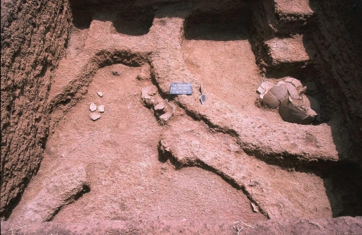
A 3 x 3 m test unit was excavated at mound 1. The location was chosen for two reasons. First, the height of the 3.5 m mound suggested a long occupational history; and second, the mound is in danger of destruction due to its proximity to the road. The unit exhibited excellent preservation of various classes of materials. Since an aim of the project is to discriminate various social units at the site, preservation is essential for isolating key spatial variation as well as for a detailed analysis of socio-economic data. Parts of 6 superimposed household compounds were uncovered throughout the sequence. In some, the mud-brick walls stood 20-30 cm high, and measurements on individual bricks were possible. Materials were collected according to various spatial contexts within each compound. For example, it was possible to sample a paved interior courtyard and three different mud-brick structures in compound 3 (Figure 3). The excellent architectural preservation was mirrored in manufactured objects and subsistence remains. All deposits were screened and flotation samples were taken from all primary contexts. Preliminary analyses of subsistence data (botanical and faunal) are currently underway to characterize the economy.
[figure]
Direct and relative dating methods will be used to establish a chronological sequence for the site. A single AMS date was submitted for analysis from a secure context 3 m below the surface of mound 1, producing a 2-sigma date for the foundation of the mound at cal AD 450-640. An estimate of abandonment around AD 1400 can be deduced through comparison with regional dates published by Holl and Koté (2000) (this will be tested through submission of other samples). Preliminary studies of the ceramics (currently underway) suggest at least two phases of occupation at Kirikongo, based upon distinct decorative techniques and vessel forms.
The exposure of mound profiles from road construction provides an invaluable opportunity to explore the occupational sequence and use of space on a mound. The 65 m long profile of Mound 1 was cleaned (only slightly, not to encourage further erosion) and recorded. Walls, floors, trash pits, and other features were identified and drawn. This mound profile will be compared against the other profiles after future seasons.
Discussion
The 2004 season provided a great deal of foundational information appropriate for the reconstruction of the socio-political structure of a prehistoric West African village. This work will help to guide and orient future research scheduled for winter 2006. The following results suggest that work at Kirikongo contains the high-resoulution data necessary for studies of community organization.
1. Kirikongo is a successful village founded in the early first millennium AD and most likely abandoned ~ AD 1400. With the establishment of an occupational chronology it will be possible to model the development or foundation point of various mounds within the group over time. In order to analyze social dynamics, it is necessary to establish contemporaneity between component parts.
2. Preliminary analyses of data from 2004 allow optimism regarding the development of a tight chronology at Kirikongo. The intact nature of the deposits and favorable preservation provide confidence in radiocarbon dates. In addition, a relative chronology based upon ceramics is already yielding results, and it is hoped that even smaller phases may be identified.
3. Excellent preservation of subsistence evidence will enable a detailed analysis of the economic basis of the village.
4. In order to examine community organization, it is necessary to identify the composite parts (social units) in the village that would interact. During the 2004 season, due to the preservation of architecture I was able to identify three levels of social unit at Kirikongo. Data indicates that the smallest spatial/social unit that can be considered is a household compound characterized by multiple residential structures (huts), pits, hearths, storage features, and a shared courtyard. Second, each separate mound may be seen as a higher-level social unit composed of multiple compounds forming a discrete residential group. Lastly, the mound complex, or village itself, is the highest-level social unit comprised of 11 mounds and many household compounds. Future work in 2006 will document the variability of different activities within the site at these three levels. The location of certain activities, and the particular social group that performs them, will provide a basis for reconstructing the organization of the community.
The results of the 2004 exploratory season of the Kirikongo Archaeological Project provide a foundation to examine the internal layout and occupational history of a mound complex in the Mouhoun Bend. Future seasons will be devoted to exploring the formal variability of the site, through a comparison of excavation units from different mounds. It is hoped that the reconstruction of the socio-political organization of an early village will contribute to comparative discussions on village social dynamics, as well as the foundations of complexity in West Africa.
quod.lib.umich.edu/cgi/t/text/text-idx?c=gefame;view=text;rgn=main;idno=4761563.0001.107
Stephen A. Dueppen
Department of Anthropology
University of Michigan
The socio-political organization of the early food-producing village is a topic of broad anthropological interest, yet the integrative mechanisms that allow the consolidation and growth of this settlement type are poorly understood (Byrd 1994, Flannery 1972, 2002). During March and April 2004, a new program of research was enacted to examine the socio-political organization of the late prehistoric village of Kirikongo located in the Mouhoun Bend of Burkina Faso. This project will address these themes through a detailed examination of the internal layout and occupational history of the settlement. The research involves multiple components, including excavation, survey, mapping, and the documentation of mound profiles. Work was conducted under the direction of the author, and with the permission of the Burkinabe Centre National de la Recherche Scientifique et Technologique (CNRST) and the Laboratoire d'Archéologie at the Université de Ouagadougou.
Archaeological evidence suggests that c. 500 BC, sedentary food-producing societies began to settle into villages and towns throughout the savanna zone of West Africa (McIntosh 1994; Breunig and Neumann 2002). However, little is known of their social and political organization. Based in a wider anthropological debate on the organizational nature of complex societies in sub-saharan Africa (e.g. Fortes and Evans-Pritchard 1940; Southall 1956), recent archaeological research has offered some preliminary understandings of the organizational features of more complex late prehistoric societies. This work has documented a variety of socio-political forms based upon a diverse material record (Holl 2002; Lawson 2003; McIntosh 1995, 1999). However, this work has been mainly centered on urban sites located along the major river drainage systems of West Africa (the Senegal, Gambia and Niger Rivers and the Lake Chad Basin). Relatively little attention has been focused on studying the basic organizational mechanisms that allowed for initial sedentary life, and are seen as foundational to the integration and growth of larger social groupings. This project, with a focus on a village along a minor drainage system will be able to address these biases.
A wide variety of settlement patterns characterize late prehistoric occupation in West Africa. In the savanna region from Mali in the west to Lake Chad in the east, a common characteristic of food-producing societies during the period is the aggregation of peoples into mounded sites. A "mound complex" is a group of mounds of varying sizes that can be considered as a single settlement; often small mounds cluster around a large primary central mound. Clustered settlements may represent many variants on a scale of complexity ranging from villages, such as Kirikongo, to more urban settlements. Although integrative mechanisms at the village level are qualitatively different from those in more urban settings, this study will contribute to our understanding of possible organizational trajectories that enabled larger social groupings.
Following Flannery (1972), the success of the village as a settlement type implies a strong organizational structure that allows for the nucleation of somehow related peoples into a single spatial unit. Settlement system research has demonstrated that the spatial/physical distance between social groups is related to cultural understandings of what constitutes a social unit (Agorsah 1993). The layout of this class of site suggests a complex internal organization, as it is composed of discrete spatial components (mounds). A study of community organization must recognize the relationships between social groups at Kirikongo in order to understand the integration of this early food-producing village. The Mouhoun Bend of NW Burkina Faso is situated near the northernmost reach of the Mouhoun River (formerly the Black Volta), where the north-flowing river makes a sharp u-shaped curve towards the south in the direction of Lake Volta (Figure 1). Preliminary archaeological investigations between 1997 and 2000 by the Mouhoun Bend Archaeological Research Project (Directed by Augustin F.C. Holl, then of UCSD, and Lassina Koté of the University of Ouagadougou) recorded a dense prehistoric occupation in the Bend (Holl and Koté 2000). They surveyed the region, documenting a diverse set of 19 mound complexes, including Kirikongo. Individual mounds range from 0.2 to 3.4 hectares in size, arranged in discrete clusters. The complex of Kirikongo contains 11 mounds, ranging in size from 0.34 to 1.43 ha in surface area, and 1.3-3.5 m in height (Figure 2).
[figure]
Figure 1: Location of occupation sites in the Mouhoun Bend
[figure]
Figure 2: Kirikongo Mound Complex, Mouhoun Province, Burkina Faso
The 2004 Season
The preliminary season of the Kirikongo Archaeological Project had three main goals. First, through survey and mapping, I aimed to identify and characterize the component parts of the village, including both cultural and natural environmental features. Second, a test unit was excavated to provide a chronology and understanding of the nature of the archaeological deposits. Third, as seen on the map, Burkina Road #10 runs directly through the site and has destroyed parts of at least four mounds (1,2,8,10). This construction has sectioned three mounds (1,2 and 8), resulting in long stretches of mound profiles. Documentation of one profile was the final activity of the season.
The survey and mapping component of the research indicates that Kirikongo contains 11 separate mounds (8 ha occupied in a 0.25 km2area). The site is comprised of a main cluster of eight mounds, with a maximum inter-mound distance of 47 m, and a set of three mounds at varying distances from the group (2 at 100 m, 1 at 150 m). An ancient quarry is situated to the southeast of mound 6, adjacent to the main cluster: it was probably used for the extraction of floor building material and possibly iron ore. In addition, a seasonal drainage was documented directly to the west of the site, only 10 m west of mound 2.
A 3 x 3 m test unit was excavated at mound 1. The location was chosen for two reasons. First, the height of the 3.5 m mound suggested a long occupational history; and second, the mound is in danger of destruction due to its proximity to the road. The unit exhibited excellent preservation of various classes of materials. Since an aim of the project is to discriminate various social units at the site, preservation is essential for isolating key spatial variation as well as for a detailed analysis of socio-economic data. Parts of 6 superimposed household compounds were uncovered throughout the sequence. In some, the mud-brick walls stood 20-30 cm high, and measurements on individual bricks were possible. Materials were collected according to various spatial contexts within each compound. For example, it was possible to sample a paved interior courtyard and three different mud-brick structures in compound 3 (Figure 3). The excellent architectural preservation was mirrored in manufactured objects and subsistence remains. All deposits were screened and flotation samples were taken from all primary contexts. Preliminary analyses of subsistence data (botanical and faunal) are currently underway to characterize the economy.
[figure]
Direct and relative dating methods will be used to establish a chronological sequence for the site. A single AMS date was submitted for analysis from a secure context 3 m below the surface of mound 1, producing a 2-sigma date for the foundation of the mound at cal AD 450-640. An estimate of abandonment around AD 1400 can be deduced through comparison with regional dates published by Holl and Koté (2000) (this will be tested through submission of other samples). Preliminary studies of the ceramics (currently underway) suggest at least two phases of occupation at Kirikongo, based upon distinct decorative techniques and vessel forms.
The exposure of mound profiles from road construction provides an invaluable opportunity to explore the occupational sequence and use of space on a mound. The 65 m long profile of Mound 1 was cleaned (only slightly, not to encourage further erosion) and recorded. Walls, floors, trash pits, and other features were identified and drawn. This mound profile will be compared against the other profiles after future seasons.
Discussion
The 2004 season provided a great deal of foundational information appropriate for the reconstruction of the socio-political structure of a prehistoric West African village. This work will help to guide and orient future research scheduled for winter 2006. The following results suggest that work at Kirikongo contains the high-resoulution data necessary for studies of community organization.
1. Kirikongo is a successful village founded in the early first millennium AD and most likely abandoned ~ AD 1400. With the establishment of an occupational chronology it will be possible to model the development or foundation point of various mounds within the group over time. In order to analyze social dynamics, it is necessary to establish contemporaneity between component parts.
2. Preliminary analyses of data from 2004 allow optimism regarding the development of a tight chronology at Kirikongo. The intact nature of the deposits and favorable preservation provide confidence in radiocarbon dates. In addition, a relative chronology based upon ceramics is already yielding results, and it is hoped that even smaller phases may be identified.
3. Excellent preservation of subsistence evidence will enable a detailed analysis of the economic basis of the village.
4. In order to examine community organization, it is necessary to identify the composite parts (social units) in the village that would interact. During the 2004 season, due to the preservation of architecture I was able to identify three levels of social unit at Kirikongo. Data indicates that the smallest spatial/social unit that can be considered is a household compound characterized by multiple residential structures (huts), pits, hearths, storage features, and a shared courtyard. Second, each separate mound may be seen as a higher-level social unit composed of multiple compounds forming a discrete residential group. Lastly, the mound complex, or village itself, is the highest-level social unit comprised of 11 mounds and many household compounds. Future work in 2006 will document the variability of different activities within the site at these three levels. The location of certain activities, and the particular social group that performs them, will provide a basis for reconstructing the organization of the community.
The results of the 2004 exploratory season of the Kirikongo Archaeological Project provide a foundation to examine the internal layout and occupational history of a mound complex in the Mouhoun Bend. Future seasons will be devoted to exploring the formal variability of the site, through a comparison of excavation units from different mounds. It is hoped that the reconstruction of the socio-political organization of an early village will contribute to comparative discussions on village social dynamics, as well as the foundations of complexity in West Africa.
quod.lib.umich.edu/cgi/t/text/text-idx?c=gefame;view=text;rgn=main;idno=4761563.0001.107


