|
|
Post by djoser-xyyman on Nov 23, 2014 14:33:13 GMT -5
Two ancient human genomes reveal Polynesian ancestry among the indigenous Botocudos of Brazil
Anna-Sapfo Malaspinas1,
Oscar Lao2, +,
Hannes Schroeder1, 3, +,
Morten Rasmussen1, 4, +,
Maanasa Raghavan1, +,
Summary
Understanding the peopling of the Americas remains an important and challenging question. Here, we present 14C dates, and morphological, isotopic and genomic sequence data from two human skulls from the state of Minas Gerais, Brazil, part of one of the indigenous groups known as ‘Botocudos’. We find that their genomic ancestry is Polynesian, with no detectable Native American component. Radiocarbon analysis of the skulls shows that the individuals had died prior to the beginning of the 19th century. Our findings could either represent genomic evidence of Polynesians reaching South America during their Pacific expansion, or European-mediated transport.
|
|
|
|
Post by truthteacher2007 on Nov 24, 2014 11:16:53 GMT -5
Two ancient human genomes reveal Polynesian ancestry among the indigenous Botocudos of Brazil Anna-Sapfo Malaspinas1, Oscar Lao2, +, Hannes Schroeder1, 3, +, Morten Rasmussen1, 4, +, Maanasa Raghavan1, +, Summary Understanding the peopling of the Americas remains an important and challenging question. Here, we present 14C dates, and morphological, isotopic and genomic sequence data from two human skulls from the state of Minas Gerais, Brazil, part of one of the indigenous groups known as ‘Botocudos’. We find that their genomic ancestry is Polynesian, with no detectable Native American component. Radiocarbon analysis of the skulls shows that the individuals had died prior to the beginning of the 19th century. Our findings could either represent genomic evidence of Polynesians reaching South America during their Pacific expansion, or European-mediated transport. I'm not surprised. It makes perfect sense that Polynesia would be one of the points of origin for the peopling of the Americas. For one thing, they had the expertise of being able to navigate open water. The Hawwaiian Islands are literally in the middle of the Pacific with no other islands close by. Somehow, they managed to colonize just aout every island in the Pacific. If they were able to make it all the way to Easter Island, which is right off the coast of Chile, what was there to stop them form venturing further? Anyway, there was also a documnetary a while back about skulls found in a cave in Brazil that were not of the expected native American type. The reconstruction and DNA analysis pointed to the South Pacific. |
|
|
|
Post by djoser-xyyman on Nov 24, 2014 13:23:52 GMT -5
Agreed. That is one of the pit-falls of eye ball anthropology as attested many “afro-centrics”. Ala Van Sertima. Evidently Polynesian type “Negros’ did navigate to the Americas before Columbus.
It was possibly done by West Africans also. But Europeans lie so much you can’t tell truth-from-fictions when they report on the matter. They are so manic to involve themselves in the peopling of the Earth.
Maybe you or any other posters can help me out. I am trying to get a “reverse” view of the Earth/Map. The picture many of us have in our minds is Africa-Atlantic Ocean-Americas. We forget the earth is round and not flat thus, Australian and the South Pacific Islands are relatively very close to the South American mainland.
I wanted to project a different point of view and build on it. The other point is, there is no “up” and “down” or North And South. Therefore it is perfectly within reason to have the Southern Hemisphere on “top”.
Remember the AEians view of the earth.
|
|
|
|
Post by djoser-xyyman on Nov 24, 2014 13:25:00 GMT -5
The earth is round.......Some locations are much closer than viewed on a "flat" map ie two dimension.
|
|
|
|
Post by truthteacher2007 on Nov 24, 2014 15:43:05 GMT -5
Agreed. That is one of the pit-falls of eye ball anthropology as attested many “afro-centrics”. Ala Van Sertima. Evidently Polynesian type “Negros’ did navigate to the Americas before Columbus. It was possibly done by West Africans also. But Europeans lie so much you can’t tell truth-from-fictions when they report on the matter. They are so manic to involve themselves in the peopling of the Earth. Maybe you or any other posters can help me out. I am trying to get a “reverse” view of the Earth/Map. The picture many of us have in our minds is Africa-Atlantic Ocean-Americas. We forget the earth is round and not flat thus, Australian and the South Pacific Islands are relatively very close to the South American mainland. I wanted to project a different point of view and build on it. The other point is, there is no “up” and “down” or North And South. Therefore it is perfectly within reason to have the Southern Hemisphere on “top”. Remember the AEians view of the earth. I know the typeof map you're talking about. It shows the correct size of the continents in relationship to each other. As far as distances, you'll have to calculate that. No map can be totally accurate because they're thrying to show a three dimensional reality on two. Anyway, it doesn't really matter how close or far they were. In real life, no one had maps. Once you're outside of sight of land you're on your own. You really have to know what you're doing. Hell, modern day people have a hard time navigating 90 miles of ocean muchless thousands. Just consider how many people drown trying to make it from Cuba or Haiti to the US, not to mention how many people drown trying to make from North Africa to Italy. However, during the ice age the sea levels would have been lower making land visable that is now under water. With regards to Van Sertima and others, they were going on the limitations of the knowledge they had available to them at the time. While I have no doubt that from time to time, West africans may have gotten caught in strong currents and ended up shipwrecked in the Americas, I see no evidence to support the idea of long term regular contact. For one thing, you would have had Meso Americans coming back to Africa as well, so things like corn, coco tomatos, etc, would have been known in Africa long before they wee introduced by European. But most importantly, the americas would have been introduced to metallurgy. All of the pre columbian societies were stone age technologies. West africans had been working iron since before the time of christ. The other thing is, why would West African had wanted to go there? What would have been the incentive? Gold? Got it already. Agricultural products? They had their own. Textiles? They made their own. Pacific Islanders on the other hand had a long history of exploration and colonization, and they were a stone age people as well. |
|
|
|
Post by anansi on Nov 25, 2014 22:21:57 GMT -5
TruthTeacher Well there were not alot of incentives to be sure as some of those civilization was the 2nd largest land empire of the time second only to the Mongols in size,however I do believe that sporadic voyages did occur we know of at-least two recorded voyages commissioned by the same king that I take seriously and that is from the Arab historian Chihab al-Umari who interviewed Mansa Musa while he was in Egypt about his succession to the throne,this I think was one of pure exploration. Now another thing while meso Americans did not developed iron making their tool kit was certainly advanced and if they were like anywhere near conservative in nature like say the Japanese nobles to the use of the firearms except one Wiley Oda NubuNaga who recognized it's potential,they may have passed it up,not to mention the iron workers in Africa may not be inclined to share their secrets as they were a closed guild caste. As for plants and transplants there is evidence of cotton exchange and some other items however some of these might well have no human carriers,and if we believe Columbus's log there may well be metal exchange as well. 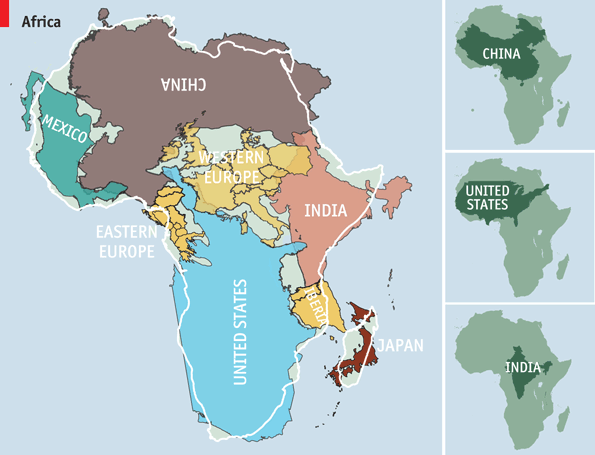  I have to admit feeling disoriented looking at the world in this way we are so used to look at the map from the other perspective. |
|
|
|
Post by snakepit on Nov 27, 2014 9:59:24 GMT -5
Agreed. That is one of the pit-falls of eye ball anthropology as attested many “afro-centrics”. Ala Van Sertima. Evidently Polynesian type “Negros’ did navigate to the Americas before Columbus. It was possibly done by West Africans also. But Europeans lie so much you can’t tell truth-from-fictions when they report on the matter. They are so manic to involve themselves in the peopling of the Earth. Maybe you or any other posters can help me out. I am trying to get a “reverse” view of the Earth/Map. The picture many of us have in our minds is Africa-Atlantic Ocean-Americas. We forget the earth is round and not flat thus, Australian and the South Pacific Islands are relatively very close to the South American mainland. I wanted to project a different point of view and build on it. The other point is, there is no “up” and “down” or North And South. Therefore it is perfectly within reason to have the Southern Hemisphere on “top”. Remember the AEians view of the earth. I know the typeof map you're talking about. It shows the correct size of the continents in relationship to each other. As far as distances, you'll have to calculate that. No map can be totally accurate because they're thrying to show a three dimensional reality on two. Anyway, it doesn't really matter how close or far they were. In real life, no one had maps. Once you're outside of sight of land you're on your own. You really have to know what you're doing. Hell, modern day people have a hard time navigating 90 miles of ocean muchless thousands. Just consider how many people drown trying to make it from Cuba or Haiti to the US, not to mention how many people drown trying to make from North Africa to Italy. However, during the ice age the sea levels would have been lower making land visable that is now under water. With regards to Van Sertima and others, they were going on the limitations of the knowledge they had available to them at the time. While I have no doubt that from time to time, West africans may have gotten caught in strong currents and ended up shipwrecked in the Americas, I see no evidence to support the idea of long term regular contact. For one thing, you would have had Meso Americans coming back to Africa as well, so things like corn, coco tomatos, etc, would have been known in Africa long before they wee introduced by European. But most importantly, the americas would have been introduced to metallurgy. All of the pre columbian societies were stone age technologies. West africans had been working iron since before the time of christ. The other thing is, why would West African had wanted to go there? What would have been the incentive? Gold? Got it already. Agricultural products? They had their own. Textiles? They made their own. Pacific Islanders on the other hand had a long history of exploration and colonization, and they were a stone age people as well. Can't be that difficult, just draw something on an orange and peel it, same principle. 5km is 5km, regardless of the fact that the surface of the earth is curved. The idea that we can't portray the surface of the earth accurately, whilst simultaneously being able to send spacecraft to mars, land 2 people on the surface of the moon for 72hrs back in the 70s, is ridiculous! |
|
|
|
Post by djoser-xyyman on Nov 27, 2014 15:04:58 GMT -5
Two ancient human genomes reveal Polynesian ancestry among the indigenous Botocudos of Brazil Anna-Sapfo Malaspinas1, Oscar Lao2, +, Hannes Schroeder1, 3, +, Morten Rasmussen1, 4, +, Maanasa Raghavan1, +, Summary Understanding the peopling of the Americas remains an important and challenging question. Here, we present 14C dates, and morphological, isotopic and genomic sequence data from two human skulls from the state of Minas Gerais, Brazil, part of one of the indigenous groups known as ‘Botocudos’. We find that their genomic ancestry is Polynesian, with no detectable Native American component. Radiocarbon analysis of the skulls shows that the individuals had died prior to the beginning of the 19th century. Our findings could either represent genomic evidence of Polynesians reaching South America during their Pacific expansion, or European-mediated transport.  |
|
|
|
Post by Tukuler al~Takruri on Nov 27, 2014 23:10:01 GMT -5
I have to admit feeling disoriented looking at the world in this way we are so used to look at the map from the other perspective. Yet this was the orientation before the European age of exploration and colonialism when they altered looks to make themselves appear on top. |
|
|
|
Post by anansi on Nov 28, 2014 0:29:13 GMT -5
True Dat Braada Al-Takruri
|
|
|
|
Post by truthteacher2007 on Nov 28, 2014 17:38:55 GMT -5
I know the typeof map you're talking about. It shows the correct size of the continents in relationship to each other. As far as distances, you'll have to calculate that. No map can be totally accurate because they're thrying to show a three dimensional reality on two. Anyway, it doesn't really matter how close or far they were. In real life, no one had maps. Once you're outside of sight of land you're on your own. You really have to know what you're doing. Hell, modern day people have a hard time navigating 90 miles of ocean muchless thousands. Just consider how many people drown trying to make it from Cuba or Haiti to the US, not to mention how many people drown trying to make from North Africa to Italy. However, during the ice age the sea levels would have been lower making land visable that is now under water. With regards to Van Sertima and others, they were going on the limitations of the knowledge they had available to them at the time. While I have no doubt that from time to time, West africans may have gotten caught in strong currents and ended up shipwrecked in the Americas, I see no evidence to support the idea of long term regular contact. For one thing, you would have had Meso Americans coming back to Africa as well, so things like corn, coco tomatos, etc, would have been known in Africa long before they wee introduced by European. But most importantly, the americas would have been introduced to metallurgy. All of the pre columbian societies were stone age technologies. West africans had been working iron since before the time of christ. The other thing is, why would West African had wanted to go there? What would have been the incentive? Gold? Got it already. Agricultural products? They had their own. Textiles? They made their own. Pacific Islanders on the other hand had a long history of exploration and colonization, and they were a stone age people as well. Can't be that difficult, just draw something on an orange and peel it, same principle. 5km is 5km, regardless of the fact that the surface of the earth is curved. The idea that we can't portray the surface of the earth accurately, whilst simultaneously being able to send spacecraft to mars, land 2 people on the surface of the moon for 72hrs back in the 70s, is ridiculous! Hope you had a nice Thanksgiving. |
|
|
|
Post by truthteacher2007 on Nov 29, 2014 11:42:39 GMT -5
TruthTeacherWell there were not alot of incentives to be sure as some of those civilization was the 2nd largest land empire of the time second only to the Mongols in size,however I do believe that sporadic voyages did occur we know of at-least two recorded voyages commissioned by the same king that I take seriously and that is from the Arab historian Chihab al-Umari who interviewed Mansa Musa while he was in Egypt about his succession to the throne,this I think was one of pure exploration. Now another thing while meso Americans did not developed iron making their tool kit was certainly advanced and if they were like anywhere near conservative in nature like say the Japanese nobles to the use of the firearms except one Wiley Oda NubuNaga who recognized it's potential,they may have passed it up,not to mention the iron workers in Africa may not be inclined to share their secrets as they were a closed guild caste. As for plants and transplants there is evidence of cotton exchange and some other items however some of these might well have no human carriers,and if we believe Columbus's log there may well be metal exchange as well. I have to admit feeling disoriented looking at the world in this way we are so used to look at the map from the other perspective. Well, like I said, I don't think it's outside of the realm of possability that there was some sort of contact, it's a matter of the nature of it. According to the account of Mansa Musa the majority of the expedition never returned. Those that did say that they came across something like a river when they were far out to sea. They stayed away from it while the other ships went with it. This sounds like an ocean current to me and indeed there is such a current that runs off the coast of Africa and goes right into the Gulf of Mexico. If memory serves me correctly Columbus and the early explorers also made mention of it. As for metal technology, even though they may have kept the actual science behind it a secrate, they most certainly would have traded ready made items. This is what happened when the English and French first made contact in North America. One of the major reasons why they were able to gain such a strong foothold is because the natives quickly developed a dependancy on metal tools like pots, axes, knives, which were far stronger than the bone and stone tools they had previously used. The Europeans never taught them how to smelt metals, but they certainly did trade them. If this were the case with Africans and Meso Americans I think we would have found metal artifacts in the Americas. So while I'm open to any definitive evidence, I remain unconvinced that there was any significant contact between the two regions. Colonization for the Pacific, yes, from Africa, no, or until such time as there is evidence for it. |
|
|
|
Post by nebsen on Nov 29, 2014 16:49:47 GMT -5
|
|
|
|
Post by djoser-xyyman on Dec 6, 2014 7:47:35 GMT -5
........>>>
Insights into the origin of rare haplogroup C3* Y chromosomes in South America from high-density autosomal SNP genotyping.
Mezzavilla M1, Geppert M2, Tyler-Smith C3, Roewer L2, Xue Y4.
Author information
Abstract
The colonization of Americas is thought to have occurred 15-20 thousand years ago (Kya), with little or no subsequent migration into South America until the European expansions beginning 0.5Kya. Recently, however, haplogroup C3* Y chromosomes were discovered in two nearby Native American populations from Ecuador. Since this haplogroup is otherwise nearly absent from the Americas but is common in East Asia, and an archaeological link between Ecuador and Japan is known from 6Kya, an additional migration 6Kya was suggested. Here, we have generated high-density autosomal SNP genotypes from the Ecuadorian populations and compared them with genotypes from East Asia and elsewhere to evaluate three hypotheses: a recent migration from Japan, a single pulse of migration from Japan 6Kya, and no migration after the First Americans. First, using forward-time simulations and an appropriate demographic model, we investigated our power to detect both ancient and recent gene flow at different levels. Second, we analyzed 207,321 single nucleotide polymorphisms from 16 Ecuadorian individuals, comparing them with populations from the HGDP panel using descriptive and formal tests for admixture. Our simulations revealed good power to detect recent admixture, and that ≥5% admixture 6Kya ago could be detected. However, in the experimental data we saw no evidence of gene flow from Japan to Ecuador. In summary, we can exclude recent migration and probably admixture 6Kya as the source of the C3* Y chromosomes in Ecuador, and thus suggest that they represent a rare founding lineage lost by drift elsewhere.
Copyright © 2014 The Authors. Published by Elsevier Ireland Ltd.. All rights reserved
|
|