So your model is to view the Sahara as a "sponge"- so to speak
and not a pump? Hmm, an interesting angle. Maybe the "pump"
analogy only holds in intense period of desiccation. The lush
green era was indeed a sponge, and I think this calls into questions approaches treating the desert as if it were some sort of static entity ...
The Sahara is passive. A pump is active. Whether wet
or dry outside actors are deciding that region's being.
The Sahara is anything but static just like you say.
SAHARA TIMELINE
• 40m sea bed (once a part of Tethys)
• 3m tropical swamp dries as desert is born
• 90k monsoon greens the region
Due to the cosmos, at least from 90k on, every 20000
years the Monsoon extends north for 5000 years. Then
it swiftly retreats back south within 200 years leaving a
desert for the next 15000 years.
Vast desert between 85k-70k doesn't support a north
east OoA route from Inner Africa. The 70k Monsoon
driven greening ended 65k. It does. 50k offers another
such window.
... I see Kush/Nubia as a both a supra-Saharan AND "sub-Saharan" entity-
from Aswan in today's Egypt, down to the approaches of Eritrea and the Horn.
SSA is a loaded term that pending the user can mean
a literal geography or a broad group of people that
may well even live in the Sahara.
Shifting sand isn't origin. It won't change any peoples'
regional origin if they get some sand all around them.
I acknowledge your Upper Nubia view. Me? The Nile Valley
is a separate region. The Lower and Middle Nile Valley
is adjacent to the Sahara from the Delta to Cataract 6.
It is neither above nor below the Sahara but beside it.
For either SSA, subSahara or supraSahara, I go by
the actual desert from satellite map. Roughly, south
of 17° is geographic subSahara. SupraSahara is very
narrow and sporadic. It's the Maghreb proper north of
the Atlas and a few tiny stretches in Libya.
I think your "sponge" model is also good in that it can explain certain physical changes in the area peoples, due to a rich foraging base, as better nutrition can impact body mass, ...
Full of freshwater lakes and their connective rivers, people
employed serious fishing skills. Fish is lean protein and a
brain food. LSA mode 5 picks up bone and microliths.
Last Moonsoon Optimum settlement at Lake Gobero Niger
shows an initial occupation of robust somewhat 'archaic'
folk. After a local dry spell people built exactly like us came.
Both were fishers with all the lifestyle benefits fishing drives.
But they were two different major peoples. One with 10000+
years of Med coastal background, the other with inner
continental antecedents and cattle and grains economy.
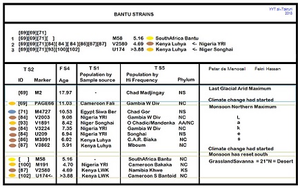
I was only interested in Inner Africa (south of 27° N).
The study is transSaharan, only considering haplogroups
from one side of the desert that show up on the other.
No E-M33 or 78, too local or young. Not even thinking
about A or B. More bang for my buck concentrating on
M2.
M2 people went north just keeping up with their
friendly neighborhood Grasslands being pushed by the
Monsoon Optimum.
GRASSLANDS TIMELINE
• 24k Guinea > L Tschad > G Lakes > SW & S
• 13k Senegal > Somalia : S Africa > L Mweru
• 10k Mauritania > Sudan : Somalia : Sn Afr
• 8k Mauritania/WnSahara > Eritrea/Egypt
• 5k Senegal > Port Sudan > Somalia : Sn Africa > L Tanganyika
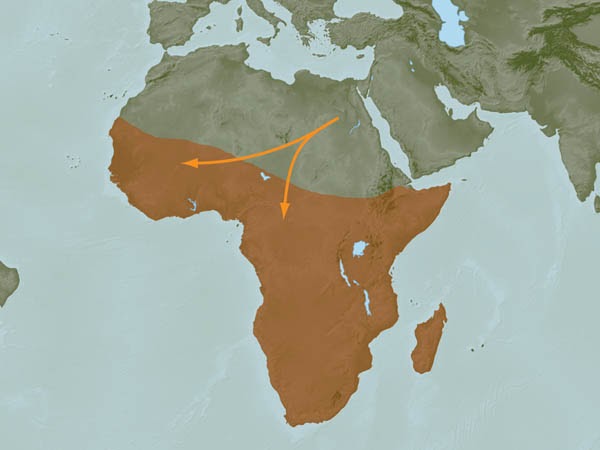
For me it's really about the Monsoon and the Grassland
pushing E-M2 and their women ever north. Then when
Monsoon and Grassland retreat south M2 folk get
pulled right along with them. That's how I see it right now.