|
|
Post by Shadow on Oct 14, 2018 12:54:54 GMT -5
Hello everyone, i'm a new user on this forum, but I been following the discussions on this website for a two years now. I would like to let everyone to know that i'm not an expert on creating threads so please go easy on me. I want to start off the discussion about something that has been on my back for a while. I recently came across an article that give various particular reasons why that the African continent has lagged behind Asia and Europe, in regards to civilization. The author of the article is basically exaggerating the lifestyles of some African's so-called difficulties to their geographic environments and somehow created a scenario where Africans were undeveloped to the point that they were relentlessly handicapped from creating solutions, techniques, and solving their problems to combat their so-called disadvantage. He also states that the idea Africans carried the Sickle Cell Virus made them vulnerable to constant death and depopulation of people on the continent. Of all that represents all Africans south of the Sahara, he makes a brief statement about it,
("Humans in Africa evolved a brutal defense against this version of malaria, the sickle cell genetic mutation, which provides some protection if you get one copy of the allele, but(without modern medicine) kills you if you inherit two. We wouldn’t have such an inelegant genetic protection if humans in Africa didn’t need it against such a massive killer. (The less vicious vivax malaria has a safer mutation to protect Africans, the Duffy gene.) So, tropical Africans couldn’t learn to live in dense urban populations, with all the advanced trades made possible by the concentrations of city life. They largely remained small villagers scratching a living from the ground.")
He simply thinks that this is the great devastation for Africans in regards to civilization, something that Africans were able to combat and become immune to. Brief links to articles about the medical practices of Traditional Africans across the continent www.ncbi.nlm.nih.gov/pmc/articles/PMC527695/ www.ncbi.nlm.nih.gov/pmc/articles/PMC4651463/
As if these various things, regarding geography and diseases weren't something that Asians and especially Europeans haven't had difficulties over. This article has been discussed all over various forum dominated by White forum users here's a link to one website discussing the same position of Africa's development status in history forum.paradoxplaza.com/forum/index.php?threads/why-didnt-africa-develop-before-the-modern-era.858888/. I mean it just ridiculous that they try to dehumanize us like that and even more ridiculous, that it haven't become an acceptable fact that many African civilizations were both equal and far ahead most Asian and European civilizations, the same positions that everyone had anyway. It shouldn't be an unfamiliar fact that in regards to Europe that during the Medieval ages Europe's was in it's economic collapse, thus calling it the Dark Ages. For those who want to know who wrote the article his name is Steve Sailer and here is the article www.unz.com/isteve/why-did-civilization-lag-in-africa/. Also, you wouldn't believe the comment sections under the article, I mean psychopathic am I right, so what are your guys response to this?
|
|
|
|
Post by Shadow on Oct 14, 2018 17:08:43 GMT -5
Hey, guys sorry for taking so long to post something, I was trying to find good materials debunking the guy's claim. Here's some more information about the legendary cities of Jenne-jeno and Timbuktu.
Jenne-jeno, an ancient African cityRoderick and Susan McIntosh excavated at Jenne-jeno and neighboring sites in 1977 and 1981 and returned in 1994 for coring and more survey, with funding from the National Science Foundation of the United States, the American Association of University Women, and the National Geographic Society (1994). This research formed the basis of their Ph.D. dissertations at Cambridge University and the University of California at Santa Barbara, respectively. The McIntoshes have published two monographs and numerous articles on their archaeological research in the Middle Niger. They are professors of anthropology at Rice University in Houston, Texas, and they continue to collaborate with Malian colleagues from the Institut des Sciences Humaines on research along the Middle Niger. For centuries, the upper Inland Niger Delta of the Middle Niger between modern Mopti and Segou has been a vital crossroads for trade. Historical sources, such as the 1828 account of the French explorer Rene Caillié, as well as local Tarikhs (histories written in Arabic) detail for us the central role that Jenne played in the commercial activities of the Western Sudan during the last 500 years. The seventeenth century author of the Tarikh es-Sudan, al-Sadi, wrote that "it is because of this blessed town that camel caravans come to Timbuktu from all points of the horizon". In the famous "Golden Trade of the Moors", gold from mines far to the south was transported overland to Jenne, then trans-shipped on broad-bottom canoes (pirogues) to Timbuktu, and thence by camel to markets in North Africa and Europe. Leo Africanus reported in 1512 that the extensive boat trade on the Middle Niger involved massive amounts of cereals and dried fish shipped from Jenne to provision arid Timbuktu. Today, the stunning mud architecture of Jenne in distinctive Sudanic style is a legacy of its early trade ties with North Africa. Three kilometers to the southeast, the large mound called Jenne-jeno (ancient Jenne) or Djoboro (Pl. 1) is claimed by oral traditions as the original settlement of Jenne. Barren and carpeted by a thick layer of broken pottery, Jenne-jeno lay mute for decades, its history and significance totally unknown. Scientific excavations in the 1970's and 1980's revealed that the mound is composed of over five meters of debris accumulated during sixteen centuries of occupation that began c. 200 B.C.E. These excavations, in addition to more than doubling the period of known history for this region, provided some surprises regarding the local development of society. The results indicated that earlier assumptions about the emergence of complex social organization in urban settlements and the development of long-distance trade as innovations appearing only after the arrival of the Arabs in North Africa in the seventh and eighth centuries were incorrect. The archaeology of Jenne- jeno and the surrounding area clearly showed an early, indigenous growth of trade and social complexity. The importance of this discovery has resulted in the entry of Jenne- jeno, along with Jenne, on the list of UNESCO World Heritage sites.
The early settlement at Jenne-jeno.It appears that permanent settlement first became possible in the upper Inland Niger Delta in about the third century B.C.E. Prior to that time, the flood regime of the Niger was apparently much more active, meaning that the annual floodwaters rose higher and perhaps stayed longer than they do today, such that there was no high land that regularly www.ruf.rice.edu/~anth/arch/niger/broch-eng.html escaped inundation. Under these wetter circumstances, diseases carried by insects, especially tsetse fly, would have discouraged occupation. Between 200 B.C.E. and 100 C.E., the Sahel experienced significant dry episodes, that were part of the general drying trend seriously underway since 1000 B.C.E. Prior to that time, significant numbers of herders and farmers lived in what is today the southern Sahara desert, where they raised cattle, sheep and goat, grew millet, hunted, and fished in an environment of shallow lakes and grassy plains. As the environment became markedly drier after 1000 B.C.E., these populations moved southward with their stock in search of more reliable water sources. Oral traditions of groups from the Serer and Wolof of Senegal to the Soninke of Mali trace their origins back to regions of southern Mauritania that are now desert. As these stone-tool-using populations slowly moved along southward-draining river systems, they found various more congenial environments. One of these was the great interior floodplain of the Middle Niger, with its rich alluvial soil and a flood regime that was well-suited to the cultivation of rice. The earliest deposits, nearly six meters deep at Jenne- jeno (Pl. 2) have yielded the hulls of domesticated rice, sorghum, millet, and various wild swamp grasses. The population that settled at Jenne-jeno used and worked iron, fashioning the metal into both jewelry and tools. This is interesting , since there are no sources of iron ore in the floodplain. The earliest inhabitants of Jenne-jeno were already trading with areas outside the region. They also imported stone grinders and beads. The presence of two Roman or Hellenistic beads in the early levels suggests that a few very small trade goods were reaching West Africa, probably after changing hands through many intermediaries. We have not detected any evidence of influences from the Mediterranean world on the local societies at this time. The original settlement appears to have occurred on a small patch of relatively high ground, and was probably restricted to a few circular huts of straw coated with mud daub. We find many pieces of burnt daub with mat impressions on them in the earliest levels. The pottery associated with this early material is from small, finely-made vessels with thin walls. Artifacts and housing material of this kind persist until c. 450 C.E., occurring over progressive larger area of Jenne-jeno. This indicates that the site was growing larger. In fact, by 450 C.E., the settlement had expanded to at least 25 hectares (over 60 acres). Jenne-jeno's floruit: 450-1100 C.E.
In the deposits dated from the fifth century, there are definite indications that the organization of society is changing. We find organized cemeteries, with interments in large burial urns (Pl. 3) as well as inhumations outside of urns in simple pits, on the edge of the settlement. From an excavation unit on the western edge of Jenne-jeno, we found evidence that the site was enlarged by quarrying clay from the floodplain and mounding it at the edge of the site New trade items appear, such as copper, imported from sources a minimum of several hundred kilometers away, and gold from even more distance mines. A smithy was installed near one of our central excavation units around 800 C.E. to mold copper and bronze into ornaments, and to forge iron. Smithing continued in this locale for the next 600 years, suggesting that craftsmen had become organized in castes and operated in specific locales, much as we see in Jenne today. The round houses at Jenne-jeno were constructed with tauf, or puddled mud, foundations, from the fifth to the ninth century. During this time, the settlement continued to grow, reaching its maximum area of 33 hectares by 850 C.E. We know that this is so because sherds of the distinctive painted pottery that was produced at Jenne-jeno only between 450-850 C.E. are present in all our excavation units, even those near the edge of the mound. And we find them at the neighboring mound of Hambarketolo, too, suggesting that these two connected sites totaling 41 hectares (100 acres) functioned as part of a single town complex (Pl. 4) . In the ninth century, two noticeable changes occur (Pl. 5) : tauf house foundations are replaced by cylindrical brick architecture, and painted pottery is replaced by pottery with impressed and stamped decoration. The source of these novelties is unknown, although we can say that they did not involve any fundamental shift in the form or general layout of either houses or pottery. So it is unlikely that any major change in the ethnic composition of Jenne-jeno was associated with the changes. Change with continuity was the prevailing pattern. One of the earliest structures built using the new cylindrical brick technology (Pl. 6) was apparently the city wall, which was 3.7 meters wide at its base and ran almost two kilometers around the town. All these indications of increasingly complex social organization are particularly important in helping us understand the indigenous context of the Empire of Ghana, an influential confederation that consolidated power within large areas to the north and west of the Inland Niger Delta sometime after 500 C.E.. To date, Jenne-jeno provides our only insight into the nature of change and complexity in the Sahel prior to the establishment of the trans-Saharan trade. Although some excavations have been conducted at the presumed capital of Ghana, Kumbi Saleh (in southeastern Mauritania), these focused on the stone-built ruins dating to the period of the trans-Saharan trade. As we currently understand the archaeology of the entire Jenne region, where over 60 archaeological sites rise from the floodplain within a 4 kilometer radius of the modern town (Pl. 7) , many of these sites were occupied at the time of Jenne-jeno's floruit between 800-1000 C.E.. We have suggested that this extraordinary settlement clustering resulted from a clumping of population around a rare conjunction of highly desirable features (Pl. 8) : excellent rice-growing soils, levees for pasture in the flood season, deep basin for pasture in the dry season and access to both major river channels and the entire inland system of secondary and tertiary marigots from communication and trade. Decline: C.E. 1200-1400In the eleventh and twelfth centuries, the first unambiguous evidence of North African or Islamic influences appears at Jenne-jeno in the form of brass, spindle whorls, and rectilinear houses. This occurs within a century of the traditional date of 1180 C.E. for the conversion of Jenne's king (Koi) Konboro to Islam, according to the Tarikh es-Sudan. After this point, Jenne-jeno begins a 200-year long period of decline and gradual abandonment, before it becomes a ghost town by 1400. We can speculate that Jenne-jeno declined at the expense of Jenne, perhaps related to the ascendancy of the new religion, Islam, over traditional practice. The continued practice of urn burial at Jenne-jeno through the fourteenth century tells us that many of the site's occupants did not convert to Islam. The production of terracotta statuettes in great numbers throughout the period and even into the fifteenth and sixteenth centuries elsewhere in the Inland Niger Delta may mark loci of resistance, within the context of traditional religious practice, to Islam or the leaders who practiced it. Whatever the cause of Jenne-jeno's abandonment, it was part of a larger process whereby most of the settlements occupied around Jenne in 1000 C.E. lay deserted by 1400. What caused such a realignment of the local population? Again, we can only speculate. Some people likely converted to Islam and moved to Jenne, where wealth and commercial opportunities were increasingly concentrated. But there is also the fact that the climate grew increasingly dry from 1200 C.E., causing tremendous political upheavals further north, and prompting virtual abandonment of whole regions (e.g., the Mema, studied by Malian archaeologist Tereba Togola) that could no longer sustain herds and agriculture. Some, if not all, of these factors were probably implicated in the decline of Jenne-jeno. Jenne-jeno is easy to reach from Jenne, and its surface traces of ancient houses and pottery are evocative of its rich history. Peering into the deep erosion gullies that scar the surface, one literally looks backward in time over 1000 years. Source: Jenne-Jeno, an African City www.ruf.rice.edu/~anth/arch/niger/broch-eng.html
Timbuktu journey to the empire of knowledge.Imagine a city in 16th century West Africa where thousands of Black African students pondered over the latest ideas in science, mathematics, and medicine. A fabled town(city) in the middle of the scorching desert, overflowing with countless numbers of valuable books, expensive crafts, exquisite fabrics, and unrivalled gold jewelry! Imagine a community of highly cultured, wealthy people whose forbidden streets were the subject of legends and whose ochre walls were sought after by some of the greatest adventurers of the times. For most people, this notion is as remote as saying, “I’m going to Timbuktu!” Yet West African people and the Berbers of the Sahara desert knew such a place and took pride in being connected to it in any way possible. Timbuktu in the sixteenth century was all of this and more! Its fabled streets were the home of one of the most respected universities in the world and its intellectuals reached the pinnacle of earthly scholarship and spiritual development. Its commercial networks stretched from below the Niger River to the Mediterranean Sea, and from the Atlantic Ocean to the Arabian Peninsula. Timbuktu was the most famous meeting place of the camel and the canoe, where the highest grade gold was exchanged for salt, cloth and other essential items. How did this fabulous city of commerce and scholarship appear on the shores of the Sahara desert? What became of its wealth of knowledge and material goods? A journey into present day Timbuktu may very well reveal some of the answers. To the Muslim world, the rulers of Mali had revealed another form of wealth. Timbuktu had become a centre of learning and a producer and exporter of rare and valuable Islamic books. Famous Muslim travelers like Ibn Battuta and Hasan al-Wazan (Leo Africanus) visited Timbuktu and were amazed at the high level of scholarship and the insatiable love for the study of the Arabic language and the Blessed Qur’an. Hasan al-Wazan wrote: Timbuktu was a principal staging point along the pilgrimage route to Makkah and thus, became a central point for scholars and travelers to the Middle East and a perfect base for the dissemination of Islamic knowledge and ideas. Thousands of manuscripts were stored in private collections and copied by local scribes for use in the many institutions of learning. The first non-Muslim to enter the city on April 20, 1828 was the French explorer Rene Caille who was disappointed at the state of the buildings of Timbuktu but noted that “apparently all of the population could read the Qur’an and even know it by heart.” The golden age had passed but the spirit of scholarship and piety still remained. Timbuktu with its thousands of manuscripts and its deep legacy destroys racist notions of Black inferiority and educational backwardness. Timbuktu gives solid proof of a powerful African past and an unbroken chain of African scholarship. Timbuktu also brings out Islam’s great legacy of development in Africa and its proper place in the annals of African achievement. It’s well preserved lessons of spirituality and peace making may very well hold some of the answers to today’s complex problems of war and never ending conflict. Maybe the heat of the desert sands and the emptiness of its expanse can provide direction for the African Renaissance and even the whole human race. Timbuktu has been designated by the African Union as one of the most important African heritage sites and has become a special building initiative of the government of South Africa. Timbuktu’s legacy refutes the racist notion of African ineriority and inability to record information. The knowledge of this history will also become a valuable tool for the Daa-íyyah who is calling to Allah in the Southern African Rennaisance of economic, cultural and political liberation. According to ‘Ali Ould Sidi and many historians of the region. Source: africanholocaust.net/islamafrica/timbuktu-empire-knowledge/
|
|
|
|
Post by Shadow on Oct 14, 2018 17:46:17 GMT -5
Here is something to get your mind around about medieval Europe. 10 dangers of the medieval periodIt was one of the most exciting, turbulent and transformative eras in history, but the Middle Ages were also fraught with danger. Here, as part of our Medieval Week, historian Dr Katharine Olson reveals 10 of the biggest risks people faced…
1. PlagueThe plague was one of the biggest killers of the Middle Ages – it had a devastating effect on the population of Europe in the 14th and 15th centuries. Also known as the Black Death, the plague (caused by the bacterium called Yersinia pestis) was carried by fleas most often found on rats. It had arrived in Europe by 1348, and thousands died in places ranging from Italy, France and Germany to Scandinavia, England, Wales, Spain and Russia. The deadly bubonic plague caused oozing swellings (buboes) all over the body. With the septicaemic plague, victims suffered from skin that was darkly discoloured (turning black) as a result of toxins in the bloodstream (one reason why the plague has subsequently been called the ‘Black Death’). The extremely contagious pneumonic plague could be contracted by merely sneezing or spitting, and caused victims’ lungs to fill up. The Black Death killed between a third and half of the population of Europe. Contemporaries did not know, of course, what caused the plague or how to avoid catching it. They sought explanations for the crisis in God’s anger, human sin, and outsider/marginal groups, especially Jews. If you were infected with the bubonic plague, you had a 70–80 per cent chance of dying within the next week. In England, out of every hundred people, perhaps 35–40 could expect to die from the plague. As a result of the plague, life expectancy in late 14th-century Florence was just under 20 years – half of what it had been in 1300. From the mid-14th-century onwards, thousands of people from all across Europe – from London and Paris to Ghent, Mainz and Siena – died. A large number of those were children, who were the most vulnerable to the disease.
2. TravelPeople in the medieval period faced a host of potential dangers when travelling. A safe, clean place to sleep upon demand was difficult to find. Travellers often had to sleep out in the open – when travelling during the winter, they ran the risk of freezing to death. And while travelling in groups provided some safety, one still might be robbed or killed by strangers – or even one’s fellow travellers. Nor were food and drink provided unless the traveller had found an inn, monastery, or other lodging. Food poisoning was a risk even then, and if you ran out of food, you had to forage, steal, or go hungry. Medieval travellers could also be caught up in local or regional disputes or warfare, and be injured or thrown into prison. Lack of knowledge of foreign tongues could also lead to problems of interpretation. Illness and disease could also be dangerous, and even fatal. If one became unwell on the road, there was no guarantee that decent – or indeed any – medical treatment could be received. Travellers might also fall victim to accident. For example, there was a risk of drowning when crossing rivers – even the Holy Roman emperor, Frederick I, drowned in 1190 when crossing the Saleph river during the Third Crusade. Accidents might also happen upon arrival: in Rome during the 1450 jubilee, disaster struck when some 200 people in the huge crowd crossing the great bridge of Sant’ Angelo tumbled over the edge and drowned. While it was faster to travel by sea than land, stepping onto a boat presented substantial risks: a storm could spell disaster, or navigation could go awry, and the medieval wooden ships used were not always equal to the challenges of the sea. However, by the later Middle Ages, sea travel was becoming faster and safer than ever before. An average traveller in the medieval period could expect to cover 15–25 miles a day on foot or 20–30 on a horse, while sailing ships might make 75–125 miles a day.
3. FamineFamine was a very real danger for medieval men and women. Faced with dwindling food supplies due to bad weather and poor harvests, people starved or barely survived on meagre rations like bark, berries and inferior corn and wheat damaged by mildew. Those eating so little suffered malnutrition, and were therefore very vulnerable to disease. If they didn’t starve to death, they often died as a result of the epidemics that followed famine. Illnesses like tuberculosis, sweating sickness, smallpox, dysentery, typhoid, influenza, mumps and gastrointestinal infections could and did kill. The Great Famine of the early 14th century was particularly bad: climate change led to much colder than average temperatures in Europe from c1300 – the ‘Little Ice Age’. In the seven years between 1315 and 1322, western Europe witnessed incredibly heavy rainfall, for up to 150 days at a time. Farmers struggled to plant, grow and harvest crops. What meagre crops did grow were often mildewed, and/or terribly expensive. The main food staple, bread, was in peril as a result. This also came at the same time as brutally cold winter weather. At least 10 per cent – perhaps close to 15 per cent – of people in England died during this period.
4. ChildbirthToday, with the benefits of ultrasound scans, epidurals and fetal monitoring, the risk for mother and baby during pregnancy and childbirth is at an all-time low. However, during the medieval period, giving birth was incredibly perilous. Breech presentations of the baby during labour often proved fatal for both mother and child. Labour could go on for several days, and some women eventually died of exhaustion. While Caesarean sections were known, they were unusual other than when the mother of the baby was already dead or dying, and they were not necessarily successful. Midwives, rather than trained doctors, usually attended pregnant women. They helped the mother-to-be during labour and, if needed, were able to perform emergency baptisms on babies in danger of dying. Most had received no formal training, but relied on practical experience gleaned from years of delivering babies. New mothers might survive the labour, but could die from various postnatal infections and complications. Equipment was very basic, and manual intervention was common. Status was no barrier to these problems – even Jane Seymour, the third wife of Henry VIII, died soon after giving birth to the future Edward VI in 1537.
5. Infancy and childhoodInfancy was particularly dangerous during the Middle Ages – mortality was terribly high. Based on surviving written records alone, scholars have estimated that 20–30 per cent of children under seven died, but the actual figure is almost certainly higher. Infants and children under seven were particularly vulnerable to the effects of malnutrition, diseases, and various infections. They might die due to smallpox, whooping cough, accidents, measles, tuberculosis, influenza, bowel or stomach infections, and much more. The majority of those struck down by the plague were also children. Nor, with chronic malnutrition, did the breast milk of medieval mothers carry the same immunity and other benefits of breast milk today. Being born into a family of wealth or status did not guarantee a long life either. We know that in ducal families in England between 1330 and 1479, for example, one third of children died before the age of five.
6. Bad weatherThe vast majority of the medieval population was rural rather than urban, and the weather was of the utmost importance for those who worked or otherwise depended on the land. But as well as jeopardising livelihoods, bad weather could kill. Consistently poor weather could lead to problems sowing and growing crops, and ultimately the failure of the harvest. If summers were wet and cold, the grain crop could be destroyed. This was a major problem, as cereal grains were the main food source for most of the population. With less of this on hand, various problems would occur, including grain shortages, people eating inferior grain, and inflation, which resulted in hunger, starvation, disease, and higher death rates. This was especially the case from the 14th through to the 16th centuries, when the ice pack grew. By 1550, there had been an expansion of glaciers worldwide. This meant people faced the devastating effects of weather that was both colder and wetter. Medieval men and women were therefore eager to ensure that weather conditions stayed favourable. In Europe, there were rituals for ploughing, sowing seeds, and the harvesting of crops, as well as special prayers, charms, services, and processions to ensure good weather and the fertility of the fields. Certain saints were thought to protect against the frost (St Servais), have power over the wind (St Clement) or the rain and droughts (St Elias/Elijah) and generally the power of the saints and the Virgin Mary were believed to protect against storms and lightning. People also believed the weather was not merely a natural occurrence. Bad weather could be caused by the behaviour of wicked people, like murder, sin, incest, or family quarrels. It could also be linked to witches and sorcerers, who were thought to control the weather and destroy crops. They could, according to one infamous treatise on witches – the Malleus Maleficarum, published in 1486 – fly in the air and conjure storms (including hailstorms and tempests), raise winds and cause lightning that could kill people and animals.
7. ViolenceWhether as witnesses, victims or perpetrators, people from the highest ranks of society to the lowest experienced violence as an omnipresent danger in daily life. Medieval violence took many forms. Street violence and brawls in taverns were not uncommon. Vassals might also revolt against their lords. Likewise, urban unrest also led to uprisings – for example, the lengthy rebellion of peasants in Flanders of 1323–28, or the Peasants’ Revolt of 1381 in England. Medieval records demonstrate the presence of other types of violence also: rape, assault and murder were not uncommon, nor was accidental homicide. One example is the case of Maud Fras, who was hit on the head and killed by a large stone accidentally dropped on her head at Montgomery Castle in Wales in 1288. Blood feuds between families that extended over generations were very much evident. So was what we know today as domestic violence. Local or regional disputes over land, money or other issues could also lead to bloodshed, as could the exercise of justice. Innocence or guilt in trials were at times decided by combat ordeals (duels to the death). In medieval Wales, political or dynastic rivals might be blinded, killed or castrated by Welsh noblemen to consolidate their positions. Killing and other acts of violence in warfare were also omnipresent, from smaller regional wars to larger-scale crusades from the end of the 11th century, fought by many countries at once. Death tolls in battle could be high: the deadliest clash of the Wars of the Roses, the battle of Towton (1461), claimed between 9,000 and 30,000 lives, according to contemporary reports.
8. HeresyIt could also be dangerous to disagree. People who held theological or religious opinions that were believed to go against the teachings of the Christian church were seen as heretics in medieval Christian Europe. These groups included Jews, Muslims and medieval Christians whose beliefs were considered to be unorthodox, like the Cathars. Kings, missionaries, crusaders, merchants and others – especially from the late 11th century – sought to ensure the victory of Christendom in the Mediterranean world. The First Crusade (1096–99) aimed to capture Jerusalem – and finally did so in 1099. Yet the city was soon lost, and further crusades had to be launched in a bid to regain it. Jews and Muslims also suffered persecution, expulsion and death in Christian Europe. In England, anti-Semitism resulted in massacres of Jews in York and London in the late 12th century, and Edward I banished all Jews from England in 1290 – they were only permitted to return in the mid-1600s. From the eighth century, efforts were also made to retake Iberia from Muslim rule, but it was not until 1492 that the entire peninsula was recaptured. This was part of an attempt in Spain to establish a united, single Christian faith and suppress heresy, which involved setting up the Spanish Inquisition in 1478. As a result, the Jews were expelled from Spain in 1492, and Muslims were only allowed to stay if they converted to Christianity. Holy wars were also waged on Christians who were widely considered to be heretics. The Albigensian Crusade was directed at the Cathars (based chiefly in southern France) from 1209–29 – and massacres and more inquisitions and executions followed in the later 13th and 14th centuries.
9. HuntingHunting was an important pastime for medieval royalty and the aristocracy, and skill in the sport was greatly admired. The emperor Charlemagne was recorded as greatly enjoying hunting in the early ninth century, and in England William the Conqueror sought to establish royal forests where he could indulge in his love of the hunt. But hunting was not without risks. Hunters could easily be injured or killed by accidents. They might fall from their horse, be pierced by an arrow, be mauled by the horns of stags or tusks of boars, or attacked by bears. Status certainly did not guarantee safety. Many examples exist of kings and nobles who met tragic ends as a result of hunting. The Byzantine emperor Basil I died in 886 after apparently having his belt impaled on the horns of a stag and being dragged more than 15 miles before being freed. In 1100, King William II (William Rufus) was famously killed by an arrow in a supposed hunting accident in the New Forest. Likewise, in 1143, King Fulk of Jerusalem died in a hunting accident at Acre, when his horse stumbled and his head was crushed by his saddle.
10. Early or sudden deathSudden or premature death was common in the medieval period. Most people died young, but death rates could vary based on factors like status, wealth, location (higher death rates are seen in urban settlements), and possibly gender. Adults died from various causes, including plague, tuberculosis, malnutrition, famine, warfare, sweating sickness and infections. Wealth did not guarantee a long life. Surprisingly, well-fed monks did not necessarily live as long as some peasants. Peasants in the English manor of Halesowen might hope to reach the age of 50, but by contrast poor tenants in same manor could hope to live only about 40 years. Those of even lower status (cottagers) could live a mere 30 years. Source: www.historyextra.com/period/medieval/10-dangers-of-the-medieval-period/While the Europeans were suffering from their economic stability, the Sahelian Empire of Ouagadougou was dominating the Saharan trade and influencing the commercial trade interest of the Moors, Sudanic, and Arabian traders of Northern Africa, as well as the Middle East. Here is a brief description of the luxurious lifestyle of the Emperor- (”The emperor, the putative heir, the dignitaries, used to litterally cover themselves with gold. Pages, horses, dogs of Tunkara or Kaya Magan were also covered with it. Only him and the heir (his sister’s son) had the right to wear cutted and sewn clothes. Other people who were following the same religion as the Tunkara, i.e. the tradition – were wearing silk, cotton loincloths, or brocade according to their resources. Men were having their beard shaved and women their head shaved. The king’s hairstyle consisted of several golden hats surrounded with very fine cotton materials. When he was granting hearing to people, to listen to their grievance and solve it, he was holding court inside a detached house in which ten horses covered by caparisons in golden materials were tied up. Ten pages wearing shields and carrying golden swords were standing behind him; the princes’ sons of his empire were standing on his right side, dressed in magnificent clothes and having their hair braided and mixed with some gold. The governor of the city was sitting on the ground in front of the king and, viziers were standing around, i.e. the Secretaries, in the same position. The door of the detached house was kept by dogs of an excellent race which almost never left the king: they were wearing gold and silver necklaces, stocked with small bells of the same metals. The noise of a drum (deba) made of a dug piece of wood, announced the opening of the session. The people was rushing, clapping hands, putting dust on their head and exposing their needs".) |
|
|
|
Post by anansi on Oct 15, 2018 4:05:10 GMT -5
Hi Shadow pls check your inbox message.
Ok as to your first post, you have more than enough information on hand to falsify their claims, that Guns Germs and Steel notion of history, have been dealt with by Zarahan and others maybe they'll chime in later.
Africans didn't lag behind anyone until after the 16th century, I think most ppl wanted more prestige buildings to say something is civilised..well Africa is not lacking in those either, vast empire , the old land had plenty, one of which took much of Southern Europe, the other expanded across the red sea and competed successfully with the Persians.
Others yet carried on long distance trade in their own vessels to faraway India and China.
Those folks simply can't get away from the Tarzan and Jane version of African histography.
|
|
|
|
Post by Shadow on Oct 15, 2018 6:02:12 GMT -5
Here are some more information on some African cities
Harar Jugol, the Fortified Historic Town (Africa's Mecca)The fortified historic town of Harar is located in the eastern part of the country on a plateau with deep gorges surrounded by deserts and savannah. The walls surrounding this sacred Muslim city were built between the 13th and 16th centuries. Harar Jugol, said to be the fourth holiest city of Islam, numbers 82 mosques, three of which date from the 10th century, and 102 shrines, but the townhouses with their exceptional interior design constitute the most spectacular part of Harar's cultural heritage. The impact of African and Islamic traditions on the development of the town's building types and urban layout make for its particular character and uniqueness.
Brief synthesis
The fortified historic town of Harar is located in the eastern part of Ethiopia, 525 km from the capital of Addis Ababa, on a plateau with deep gorges surrounded by deserts and savannah. The walls surrounding this sacred city, considered “the fourth holy city” of Islam, were built between the 13th and 16th centuries and served as a protective barrier. There were five historic gates, which corresponded to the main roads to the town and also served to divide the city into five neighbourhoods, but this division is not functional anymore. The Harar gate, from where the main streets lead to the centre, is of recent construction.
Harar Jugol numbers 82 mosques, three of which date from the 10th century, 102 shrines and a number of traditional, Indian and combined townhouses with unique interior designs, which constitute a spectacular part of Harar's cultural heritage. The African and Islamic traditions influenced over a long period of time the development of the city and its typical urban planning and contributed to its particular character and uniqueness. The present urban layout follows the 16th century design for an Islamic town with its central core occupied with commercial and religious buildings and a maze of narrow alleyways with imposing facades. The traditional Harari house has a typical, specific and original architectural form, different from the domestic layout usually known in Muslim countries, although reminiscent of the coastal Arab architecture, and with an exceptional interior design. At the end of the 19thcentury Indian merchants built new houses with wooden verandas that defined a different urban landscape and influenced the construction of the combined Indian/Harari houses. Their architectural and ornamental qualities are now part of the Harari cultural heritage.
Harar functioned as the capital of the Harari Kingdom from 1520 to 1568, became an independent emirate in the 17th century and was integrated into Ethiopia in 1887. From the late 16th century to the 19th century Harar was an important trade centre between the coast and the interior highlands and a location for Islamic learning.Today Harar is the administrative capital of the Harari People National Regional State (HPNRS). The historic town has a traditionally functioning community, forming a complex social-environmental whole where each element has its symbolic and practical significance. The Harari people are distinguished by the continued cultural traditions and quality of their handicrafts, including weaving, basket making and book binding. The organization of the communities through traditional systems has preserved its social and physical inheritance and, significantly, the Harari language.
Criterion (ii): The historic town of Harar Jugol exhibits an important interchange of values of original Islamic culture, expressed in the social and cultural development of the city enclosed within the otherwise Christian region. Such influences have been merged with traditions that relate to the inland of Africa and particularly to southern Ethiopia, giving a particular characteristic form to its architecture and urban plan.
Criterion (iii): Harar Jugol bears exceptional testimony to cultural traditions related to Islamic and African roots. It is considered “the fourth holy city” of Islam, having been developed by a holy missionary from the Arabic Peninsula. Though a trading place and thus a melting pot of various influences, Harar has been in relative isolation in its region, contributing to a cultural specificity, expressed in its characteristic community structure and traditions, which are still alive.
Criterion (iv): Harar Jugol is an outstanding example of a type of architectural and urban ensemble which illustrates the impact of African and Islamic traditions on the development of specific building types. The building types and the entire urban layout reflect these traditions, which give a particular character and even uniqueness to Harar Jugol.
Criterion (v): Harar Jugol with its surrounding landscape is an outstanding example of a traditional human settlement, representative of cultural interaction with the environment. The social and spatial structure (afocha) and the language of the people all reflect a particular and even unique relationship that there developed with the environment. The cultural and physical relationships with the territory have survived till today, but they are also vulnerable to irreversible change under the impact of the modern globalizing world.
Integrity
The inscribed property of Harar Jugol has a core zone of 48 ha which encompass the entire walled city and contains all the attributes that sustain the Outstanding Universal Value of the property. The buffer zone extends 800m to the south and 1700m to the east whilst, on the west side, it is narrow and confined by the new town of Harar. Urban encroachment, on the western edge of the walled town, is the current concern.
Although there have been some urban development towards the west and north parts, the historic city remains intact on the eastern and south-eastern part of the walled town where the essential relationship between the urban and rural areas is still maintained.
Except for some changes that took place in the 19th and 20th centuries, such as the replacement of the principal Mosque by the Orthodox Church, and the enlargement of the main street leading from the western gate, the historic city has kept its traditional housing reasonably intact.
However, the integrity of the property can be threatened by emerging trends to alter and modernize the traditional buildings, which would make them susceptible to irreversible change. Careful monitoring, enforcement of regulations, raising awareness and the promotion of preservation attitudes amongst the inhabitants are actions needed to maintain integrity.
Authenticity
Harar Jugol is a rare example of a relatively well preserved historic town that has retained its traditions, urban fabric, and rich Harari Muslim cultural heritage to the present time. It is one of the holy towns of Islam in Africa, and the capital of a minority region within Christian Ethiopia. The historic city is physically limited and well defined by its 16th century surrounding wall and the setting has been retained along the eastern and south-eastern sides of the property. However, inappropriate interventions, such as plastering the houses, changing doors from wood to metal, the introduction of non-traditional materials and visual impacts such as TV antennas have been gradually affecting the authenticity of the historic fabric. Guidelines for interventions need to be enforced and communicated amongst the inhabitants to prevent further impacts on the authenticity of the property.
Protection and management requirements
Harar has been officially registered as an Ethiopian National Heritage site since 1974. The legislative framework which protects the property includes the “Heritage Conservation Draft Proclamation of Harari People National Regional State” (January 2000), "The Establishment of Harar Heritage Conservation Office" (Proclamation no. 21/1992) and the Federal Proclamation no. 209/2000 for “Research and Conservation of Cultural Heritage”. In addition, four levels of protection have been identified for the property within the Management Plan: principal monuments, important historic buildings, contextual urban fabric and ‘out-of-context’ buildings.
The Centre for Research and Conservation of Cultural Heritage (ARCCH), established in 1976, is responsible for the inventory and the definition of conservation policies, providing support for restoration work, and making decisions over grants and permits. The local authority and the Kebele act as administrative offices in the process. The Jugol Heritage Conservation Office (JHCO), established in 2003, has a management committee and serves as a liaison between the Harari Counsel, under the General Meeting of the Harari People National Regional State, and representatives of the administrative and social structure in Jugol. The main source of funding comes from the government. However, there has been cooperation between the local authority, the Urban Development Support Service, and the German Technical Organization.The Urban Master Plan and the GIS system that inventories historic structures are tools to drive decision-making at the property. The Master Plan has the main objectives of preserving historic heritage, improving living conditions for the inhabitants and the promotion of tourism in addition to the conservation of the agricultural landscape in the buffer zone. Factors that need to be addressed through management and conservation actions include the enforcement of regulations for new constructions, infrastructure development, waste management, the maintenance and conservation of historic buildings as well as the preservation of the setting. The management of Harar Jugol will need to address the challenges faced to achieve the delicate balance between the need for conservation of cultural heritage and traditional values with those for the improvement of quality of life and sustainable development.
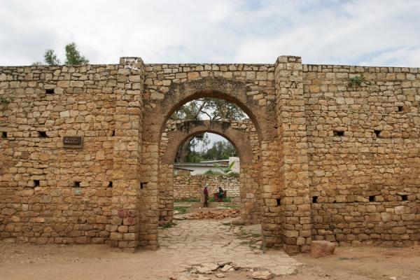
(Fortified wall of Harar Jugol)

(Another area of the city)
Source: whc.unesco.org/en/list/1189
The City of Mombasa
 (1572 Mombasa by Gorge Braun) (1572 Mombasa by Gorge Braun)
 (An old photograph of the city) (An old photograph of the city) (Modern city of Mombasa)  (The elaborate, hand carved coastal doors) (The elaborate, hand carved coastal doors)
Founding of the City
The founding of Mombasa is associated with two rulers: Mwana Mkisi (female) and Shehe Mvita. According to oral history and medieval commentaries, Shehe Mvita superseded the dynasty of Mwana Mkisi and established his own town on Mombasa Island. Shehe Mvita is remembered as a Muslim of great learning and so is connected more directly with the present ideals of Swahili culture that people identify with Mombasa. The ancient history associated with Shehe Mvita and the founding of an urban settlement on Mombasa Island is still linked to present-day peoples living in Mombasa. The Thenashara Taifa (or Twelve Nations) Swahili lineages recount this ancient history today and are the keepers of local Swahili traditions. Even though today Mombasa is a very heterogeneous cultural mix, families associated with the Twelve Nations are still considered the original inhabitants of the city.
Glory of the cityRenowned for its cultural diversity, its ornate balconies, intricately carved doors and precariously narrow streets, the old town of Mombasa serenely sits by the edge of the sea like an old man reflecting on a life well lived. The town which spans an area of approx 180 acres was the first settled area on the island. It is believed to have been primarily started by members of the Swahili ethnic group. As you would imagine, a post titled ‘Mombasa old town, then and now’ would naturally take you the reader through a series of both past and present photos ( which I assure you it will). But this time round, think of it as more of a journey back and forth through time. A journey which like any other, has its fair share of setbacks, adventures and wonderful encounters. We begin somewhere in the 12th century as we accompany the famed geographer and cartographer Al Idrisi on his travels around the world. In his work, Al Idrisi gives the first published reference to Mombasa. His citing enabled historians to estimate that the town was probably founded ca. 1000. (Although there is no agreement as to exactly when or who founded it) In the spring of 1331, another notable figure visited the town. The acclaimed Moroccan explorer Ibn Battuta traveled south along the East African coast from Aden to Mogadishu, Mombasa and down to Kilwa, center of the Kilwa Sultanate. At its height, the sultanate claimed lordship over most mainland and island states along the Swahili Coast, Mombasa being one of them. Ibn Battuta, who spent one night in the town described Mombasa as.. ” a large island with two days journey by sea between it and the land of the “Sawãhil”. It has no mainland. Its trees are the banana, the lemon, and the citron. They have fruit which they call the “jammun”, which is similar to the olive ….the people are a religious people, trustworthy and righteous. Their mosques are made of wood, expertly built. At every door of the mosques there are one or two wells… At this time, the town was still relatively small. It hardly had the air of a town that would grow into a major port or a thriving commercial center. It would take a while for the young town to find its ground but this was a very short time compared to the years of prosperity that were soon to follow… Our next stop over, the 16th century… It’s been close to 300 years of slow but steady trade and growth... Source: informationcradle.com/kenya/history-of-mombasa/
|
|
|
|
Post by zarahan on Oct 15, 2018 8:39:57 GMT -5
Hi Shadow pls check your inbox message. Ok as to your first post, you have more than enough information on hand to falsify their claims, that Guns Germs and Steel notion of history, have been dealt with by Zarahan and others maybe they'll chime in later. Africans didn't lag behind anyone until after the 16th century, I think most ppl wanted more prestige buildings to say something is civilised..well Africa is not lacking in those either, vast empire , the old land had plenty, one of which took much of Southern Europe, the other expanded across the red sea and competed successfully with the Persians. Others yet carried on long distance trade in their own vessels to faraway India and China. Those folks simply can't get away from the Tarzan and Jane version of African histography. Yeah, the very info he posted already answered his question, so why is he asking the same repetitive question unless he is trolling? The OP is suspicious, and is based on old material from 2014. "Innocent" inquires now? It is also suspiciously similar to what was dealt with back in 2015 per below. egyptsearchreloaded.proboards.com/thread/2019/academic-bulletin-post-correctAnd the very pages given on racist "HBD" leader Steve Sailer's laughable African claims, features a thorough 8-part debunking of said claims back in 2014 by one Enrique Cardova. So why come to Reloaded now to "inquire"? Methinks some of this is just trolling this old material- typical tactic of HBD types.. Fully debunked, they keep raising the same issues as if by repetition, they can erase the verdict already delivered demolishing their nonsense. They can "recycle" all they want, it still makes no difference. They still stand debunked. As for the article on malaria it is about traditional African medicinal practices and has little to with any "civilizational lag." In fact, some modern cures are based on the traditionals- quote: "Traditional medicines have been used to treat malaria for thousands of years and are the
source of the two main groups (artemisinin and quinine derivatives) of modern antimalarial drugs."The "logic" at work is also laughable. If Africans evolved sickle-cell against malaria, then that is actually a POSITIVE to enable cultures to survive, just as Europeans evolved genetic defenses against various diseases, including use of possible Nanderthal genetic material to aid immune systems. (Quach et al 2016- Genetic Adaptation and Neandertal Admixture..) If Africans were surviving, how is that "great devastation for Africans in regards to civilization"? "Sickle-cell" mutation did not prevent the empires of West Africa from being built, nor the great empires of Kemet or Nubia where sickle cell mutation also appears. LOL.. if anything the sickle-cell areas are among the more advanced areas of African civ.. ha aha haaha... These people lack even elementary logic. They don;t get it or can;t accept the facts, so they have to keep repeating the same questions as if that changes anything.. And tropical Africans actually did in various parts live "in dense urban populations," with "all the advanced trades made possible by the concentrations of city life.." as demonstrated back in 2014. In West Africa, Kano had about 75,000 in the late 1500s, and Niani, capital of Mali had 60,000 inhabitants in 1324, MORE than contemporary London. Its already on Sailer's page there. So how come some people claim that they can't find the answers, unless they are trolling? But, assuming this is genuine, in any event, here's a recap: ---------------------------------------------------------------------- 8 debunkings- re- "civilizational lag" in Africa- bogus claims exposed1) [COntrary to Sailer's claim] Acemoglu et al do not blame “extractive” versus “inclusive” institutions as an all purpose explanation for “anything bad that ever happened anywhere in the history of the world.” This is not what they say. 2) Sailer’s comparison of the tropical Africa o the tropical Yucatan Mexico also misses the ball. Africa was not “far behind” other tropical places such as the Yucatan. In fact Africa produced some of the most sophisticated large scale civilization in human history- in the Nile Valley. And almost 20% of Egypt falls within the tropical belt. Its fundamental peopling was by tropical Africans (Zakrewski 2004, 2007; Yurco 1996, 1989, Keita 2005, 1992; Lovell 1999; et al) not the “Middle Easterners” or Europeans” or Asiatics (like Greeks, Romans, Assyrians, Persians, Hyskos, Arabs etc) who were only to come in significant numbers later. Here’s what conservative anthropologist Nancy Lovell, someone recommended by Mary Lefkowitz herself has to say about that: “There is now a sufficient body of evidence from modern studies of skeletal remains to indicate that the ancient Egyptians, especially southern Egyptians, exhibited physical characteristics that are within the range of variation for ancient and modern indigenous peoples of the Sahara and tropical Africa.. must be placed in the context of hypotheses informed by archaeological, linguistic, geographic and other data. In such contexts, the physical anthropological evidence indicates that early Nile Valley populations can be identified as part of an African lineage, but exhibiting local variation.” –Nancy C. Lovell, ” Egyptians, physical anthropology of,” in Encyclopedia of the Archaeology of Ancient Egypt, 1999). pp 328-332 . 3) Sailer’s “litmus test” of big ruins is undermined by the fact that: (a) the African peoples of the Nile Valley produced structures equal or greater. Egypt obviouslygets more press but “Sub-Saharan” Africa includes the kingdom of Kush, which had its own writing system, iron industry and monumental construction. The southward movement of the Sahara obscures this fact, making numerous African cultures far to the north “sub-Saharan. Kushite civilization documented by credible scholars along these lines easily produces plenty of ruins and monuments. (b) Impressive stadium like ruins are scarce in ancient “hotbeds” of Caucasoid purity- northern Europe for example. They are scarce in the territory of virtuous Nordics or Germanics- appearing neither or barely in ancient Germany, Sweden, Holland, France etc etc. The British Isles are no different- where are the pyramids of Wales for example? Stonehenge in England is one of the few big northern European monumental constructs, but this is more than matched in the Nile Valley and the Kingdom of Kush in the Sudan- itself a “sub-Saharan” entity that produced its own ancient pyramids and burial complexes, despite a resource base that had a fraction of what was available to their Egyptian cousins on the much vaster, more populous territories of the northward Nile. Then there is the kingdom of Askum – sub-Saharan- which produced monoliths weighing 700 tons as Reader himself notes. . 4) Sailer claims John Reader’s argument is that the reason there are few ruins is because there was little wealth in sub-Saharan Africa before outside interventions . This is untrue. Reader makes no such claims. In fact Reader repeatedly shows Africa had plenty of sophisticated civilizations and wealth long before any outsiders showed up. Reader does manage to mention monumental construction in Africa’s Nile Valley which includes the Kingdom of Kush – itself a sub-Saharan entity with administrative links deep into the Sudan and trade links as far afield as Central Africa. QUOTE: “the wealth and power of Meroe at its height during the last few centuries BC is not at all surprising, particularly since the island of Meroe was also richly endowed with both iron ore and the hardwood timber needed for charcoal.. Among the monumental ruins of a civilization lying today on the island of Meroe, huge mounds of slag testify to the scale of iron production that powered its rise and ultimately brought about its downfall… “Even iron-smelting technology, so powerful a formative element of the Meroe civilization, is older in West and central Africa and therefore cannot have been introduced from Meroe.. any residual feeling that Egypt or Nubia must have been responsible for developments in sub-Saharan Africa will have to be abandoned and Bantu-speaking people accepted as innovators in their own right.”–Reader (pages 191-199) Finally Reader mentions Askum- a “sub-Saharan” African civilization with plenty of big ruin- QUOTE: “The early Askumites built in stone. They erected massive carved monoliths over the graves of their leaders (one was 33 meters long and weighed over 700 tonnes, arguably the largest single piece of worked stone ever hewn.” (Reader, pg 208). In short, Reader is not saying what Sailer claims he said- quite the contrary. . 5) Sailer correctly notes the environmental problems, but such problems also appear in Europe. White “role models” in parts of Europe lacking good soils or having environmental disadvantages, such as Ireland, or the Balkans did not accumulate much wealth either. Africa is nothing special in this regard. Such mundane things as geography, climate etc etc- points long observed by Thomas Sowell in his “Culture” trilogy some years before Reader, or his Ethic America (1981) almost 2 decades before Reader’s tome. . . 6) “Tropical Africans” would include the Africans of Egypt and the Sudan, where there were indeed recognizable urban populations. But lack of urbanization is nothing special. As late as the 1700s Early Industrial Revolution era, China for all its advances only had about 3-4% of its population urbanized (W. Easterly 2014 The Tyranny of Experts. 146). As late as 1914, only 14-15% of Russia, a massive land, was urbanized. London as late as the 1500s had a mere 50,000 inhabitants, smaller than contemporary Cairo on the African continent (Urban World History: An Economic and Geographical Perspective By Luc-Normand Tellier 2009) . 7) Sailer’s claims on Europe exercising “sexual restraint” for ‘darwinian advantages” are illogical and untrue. In fact high child mortality rates in historical Europe did encourage “thoughtless procreation,” with the simple logic that the more children on hand, the more chance some might survive that mortality. Just as Europeans found it advantageous to have plenty of children to ride out high child mortality, so also Africans found it advantageous to have plenty of children to ride out the impact of the debilitating wave of tropical diseases that cut down their children. . 8) Sailer also fails to grasp that in Africa, high procreation rates are themselves a parental investment to ensure some survivability into the next generation. Until they die those children have to be fed or cared for. Furthermore as credible scholars have long shown, Africa has the lowest infanticide rate in the world, far below supposedly more virtuous European or Asiatic “role models” (QUOTE: “Africa has been reported to have a lower incidence of infanticide than all of the other continents.” –Milner, L.S. (2000). Hardness of Heart / Hardness of Life: the stain of infanticide. University Press. p. 160 ) Hardly a picture of missing “parental investment.” Harry flashman says: Kush was a very late bloomer and was a source of slaves. When Kushites invaded Egypt they essentially copied Egyptians. Then dismantled the place. The Assyrians kicked out Taharqo.[/b] Laughable. Kush was around since 2000BC, and in fact, around 1550-1570 BC during the 17th dynasty, almost overran Egypt. And in fact they were a power in their own right- not only during and after the dynastic era, but pharaonic culture in part is closely related to and derives from Nubian precursors. As for slavery, Palestine and Mesopotamia also furnished numerous slaves in antiquity. And the Nubian pharaohs circa 800BC actually were RESTORATIONISTS of ancient Egyptian culture. After the Persians defeated the Egyptians to end the dynastic era, the Kushites built up the powerful Meriotic kingdoms to the south that were not mere copies of Egypt but independent cultural entities in their own right as credible scholars show. (K. Schillingford, 2004. A history of sub-Saharan Africa). As for copying, Europe itself is a massive copier and borrower – from things like writing, to key plant and animal domesticates, to even cultural products like Christianity, which did not come from Europe but from people called Jews in the sub-tropical the Middle East. quote: Far from Egypt being the supreme power of the Nile Valley, clearly Kush was at that time. “Had they stayed to occupy Egypt, the Kushites might have eliminated it. That’s how close Egypt came to extinction.” –Vivian Davies, Director, British Museum-Department of Ancient Egypt and Sudan. 2004 on the Kushite invasion- El-Kab, 17th Dynasty Scara Brae is in the tip of Scotland and is as old a settlement as you’d find.As for Skara Brae, it is rather unimpressive. It is a Neolithic village that produced very little of the “big” monumental pieces talked about by Sailer. You are trying to puff it up with dubious assertion, but it consists of a mere eight clustered houses. Readers can check out the “massive” houses of the little village below. www.orkneyjar.com/history/skarabrae/Flimflam. The South East of England was densely populated.We are not talking about density of population over a big region, but URBANIZATION density in that earlier time as discussed by Sailer. Cairo today still has more people than London, but in that earlier time, credible scholars show that Africa had city populations quite comparable with, or exceeding other cities in several contemporary European kingdoms.. Africa did not have massively dense urban populations everywhere, but neither did many parts of Europe. In fact some African cities exceed in population or compare favorably- Algiers in the 1600s had 150,000, Mekenes in Morocco 200,000. In West Africa, Kano had about 75,000 in the late 1500s, and Niani, capital of Mali had 60,000 inhabitants in 1324. (James Tarver 1996- The Demography of Africa- pg 93). Reader himself also notes (page 225) that complex urban societies arose in West Africa a millennia before Arab arrival. QUOTE: “West African history was ‘unshackled from the Arab stimulus paradigm in the 1970s.. wherein the transformation to a complex urban society began 1,000 years before the arrival of the Arabs.” ^^That’s Sailer’s own reference, Reader, speaking, page 225. Furthermore dispersed African urbanization patterns are nothing unusual. In fact Reader shows they are comparable to China’s urbanization pattern, in similarly situated eras. Quote: “Remarkably similar settlement processes appear to have characterized the urbanization process at sites of similar age in China, suggesting that this alternative to hierarchical social system and coercive centralized control strategy of classical definition may have occurred worldwide..” You really need to get a grasp of modern archaeology and history, and what Reader actually said as opposed to what someone CLAIMS he said. |
|
|
|
Post by Shadow on Oct 15, 2018 12:14:39 GMT -5
Zarahan, I was actually debunking an article, that was titled "Why Did Civilization Lag in Africa", when I first greeted myself to everyone. I wasn't actually asking a question of any kind, thus the reason I posted the various information in the thread to debunk the author. Also, I rest assure you that i'm not a troll, a goblin, or Devil of any kind, so you don't have to be suspicious of anything that is going on.
|
|
|
|
Post by Tukuler al~Takruri on Oct 15, 2018 14:02:41 GMT -5
Hey, guys sorry for taking so long to post something, I was trying to find good materials debunking the guy's claim. Here's some more information about the legendary cities of Jenne-jeno and Timbuktu.
Jenne-jeno, an ancient African city Excellent new and refresher info on the main Inland Niger Delta cities prehistory. Good for the experienced and newbies alike. Wish I had that archeology when I wrote |
|
|
|
Post by Tukuler al~Takruri on Oct 15, 2018 14:24:58 GMT -5
Lot of good stuff in this thread reminding how it was at 1st contact before it came down to How Europe underdeveloped AfricaWalter Rodney [/b] Bogle-L'Ouverture Publications, 1972 Angela Davis writes the latest edition's foreword. My opinion? Shoddy inexpensive mass produced imported implements undermined local manufactures in the market to devastating effect on industry, technology, and engineering. [/quote][/b] Zarahan, I was actually debunking an article, that was titled "Why Did Civilization Lag in Africa", when I first greeted myself to everyone. I wasn't actually asking a question of any kind, thus the reason I posted the various information in the thread to debunk the author. Also, I rest assure you that i'm not a troll, a goblin, or Devil of any kind, so you don't have to be suspicious of anything that is going on. |
|
|
|
Post by Shadow on Oct 15, 2018 16:39:08 GMT -5
Here are some more information on some ancient Nigerian cities The Grand Capital of BeninThis is the story of a lost medieval city you’ve probably never heard about. Benin City, originally known as Edo, was once the capital of a pre-colonial African empire located in what is now southern Nigeria. The Benin empire was one of the oldest and most highly developed states in west Africa, dating back to the 11th century. The Guinness Book of Records (1974 edition) described the walls of Benin City and its surrounding kingdom as the world’s largest earthworks carried out prior to the mechanical era. According to estimates by the New Scientist’s Fred Pearce, Benin City’s walls were at one point “four times longer than the Great Wall of China, and consumed a hundred times more material than the Great Pyramid of Cheops”. Situated on a plain, Benin City was enclosed by massive walls in the south and deep ditches in the north. Beyond the city walls, numerous further walls were erected that separated the surroundings of the capital into around 500 distinct villages. Pearce writes that these walls “extended for some 16,000 km in all, in a mosaic of more than 500 interconnected settlement boundaries. They covered 6,500 sq km and were all dug by the Edo people … They took an estimated 150 million hours of digging to construct, and are perhaps the largest single archaeological phenomenon on the planet”. Barely any trace of these walls exist today. Benin City was also one of the first cities to have a semblance of street lighting. Huge metal lamps, many feet high, were built and placed around the city, especially near the king’s palace. Fuelled by palm oil, their burning wicks were lit at night to provide illumination for traffic to and from the palace. When the Portuguese first “discovered” the city in 1485, they were stunned to find this vast kingdom made of hundreds of interlocked cities and villages in the middle of the African jungle. They called it the “Great City of Benin”, at a time when there were hardly any other places in Africa the Europeans acknowledged as a city. Indeed, they classified Benin City as one of the most beautiful and best planned cities in the world. In 1691, the Portuguese ship captain Lourenco Pinto observed: "Great Benin, where the king resides, is larger than Lisbon; all the streets run straight and as far as the eye can see. The houses are large, especially that of the king, which is richly decorated and has fine columns. The city is wealthy and industrious. It is so well governed that theft is unknown and the people live in such security that they have no doors to their houses.” In contrast, London at the same time is described by Bruce Holsinger, professor of English at the University of Virginia, as being a city of “thievery, prostitution, murder, bribery and a thriving black market made the medieval city ripe for exploitation by those with a skill for the quick blade or picking a pocket”. (1668 View of Benin City, by the Dutch Traveler Olfert Dapper.) 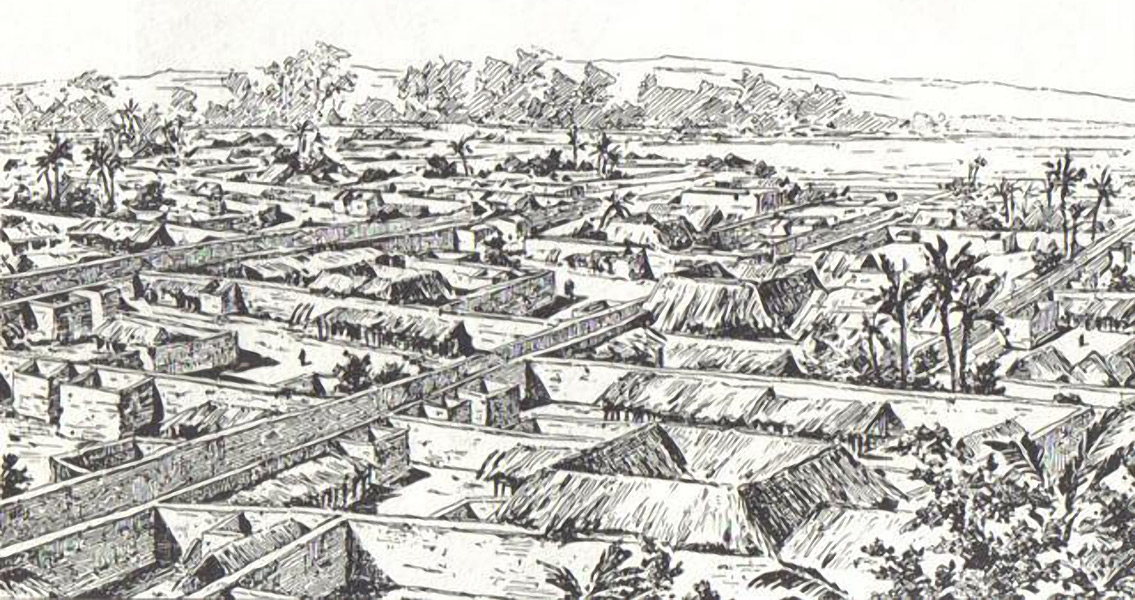 (An 19th century engraving of the city) 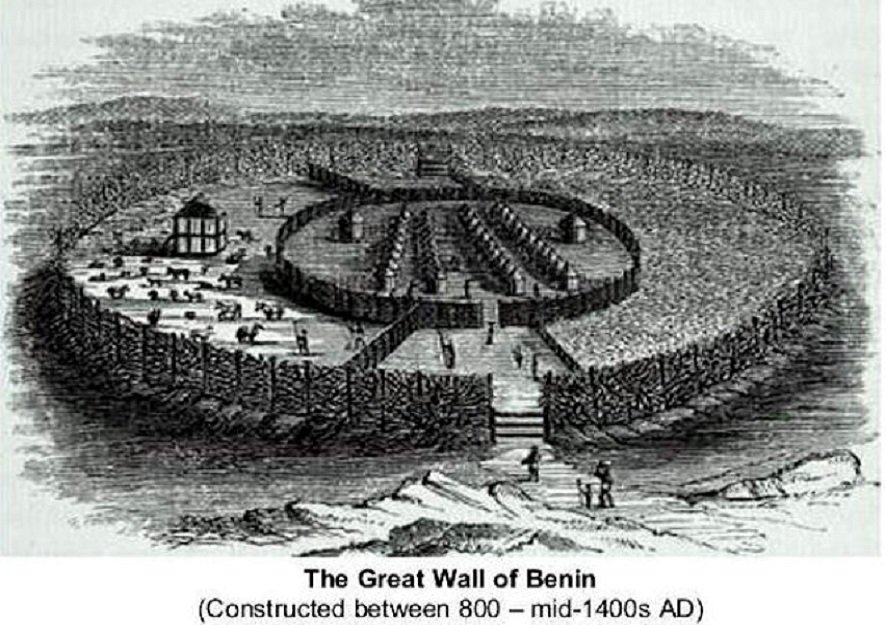 (An 19th century engraving of the defensive walls of the city) 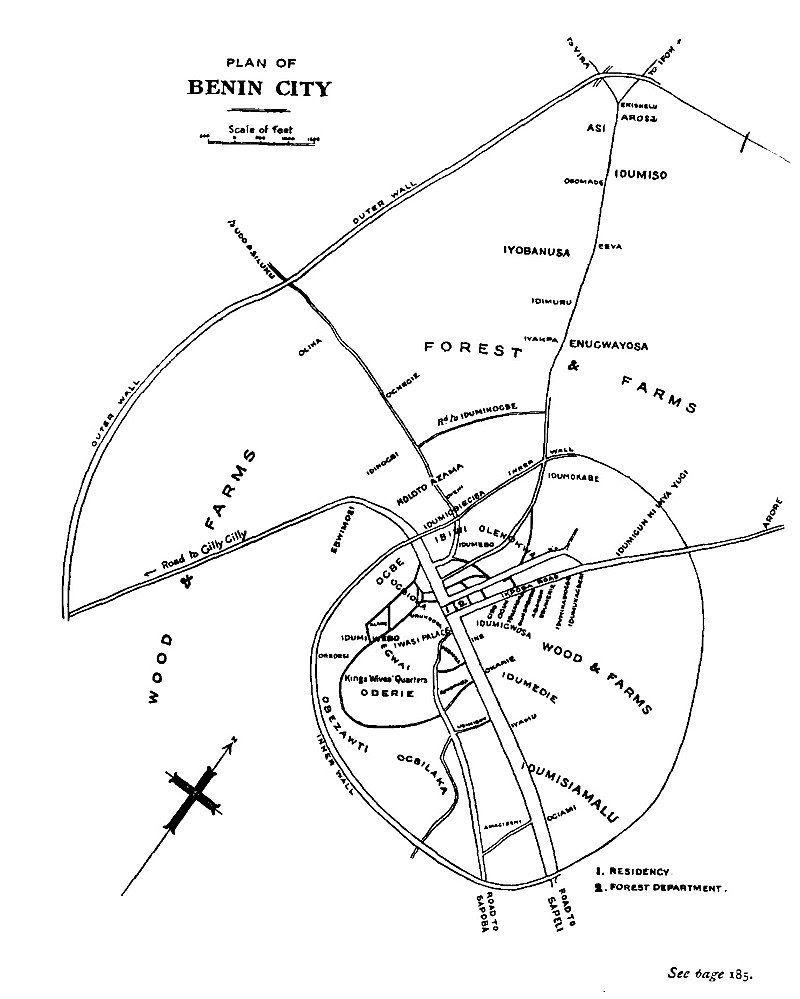 (Plan of the city)  (Another plan of the city) Information on the Design of the CapitalBenin City’s planning and design was done according to careful rules of symmetry, proportionality and repetition now known as fractal design. The mathematician Ron Eglash, author of African Fractals – which examines the patterns underpinning architecture, art and design in many parts of Africa – notes that the city and its surrounding villages were purposely laid out to form perfect fractals, with similar shapes repeated in the rooms of each house, and the house itself, and the clusters of houses in the village in mathematically predictable patterns. As he puts it: “When Europeans first came to Africa, they considered the architecture very disorganised and thus primitive. It never occurred to them that the Africans might have been using a form of mathematics that they hadn’t even discovered yet.” A plaque showing an entrance to the palace of the Oba of Benin. At the centre of the city stood the king’s court, from which extended 30 very straight, broad streets, each about 120-ft wide. These main streets, which ran at right angles to each other, had underground drainage made of a sunken impluvium with an outlet to carry away storm water. Many narrower side and intersecting streets extended off them. In the middle of the streets were turf on which animals fed. “Houses are built alongside the streets in good order, the one close to the other,” writes the 17th-century Dutch visitor Olfert Dapper. “ Adorned with gables and steps … they are usually broad with long galleries inside, especially so in the case of the houses of the nobility, and divided into many rooms which are separated by walls made of red clay, very well erected.”
Dapper adds that wealthy residents kept these walls “as shiny and smooth by washing and rubbing as any wall in Holland can be made with chalk, and they are like mirrors. The upper storeys are made of the same sort of clay. Moreover, every house is provided with a well for the supply of fresh water”. Family houses were divided into three sections: the central part was the husband’s quarters, looking towards the road; to the left the wives’ quarters (oderie), and to the right the young men’s quarters (yekogbe). Daily street life in Benin City might have consisted of large crowds going though even larger streets, with people colourfully dressed – some in white, others in yellow, blue or green – and the city captains acting as judges to resolve lawsuits, moderating debates in the numerous galleries, and arbitrating petty conflicts in the markets. The early foreign explorers’ descriptions of Benin City portrayed it as a place free of crime and hunger, with large streets and houses kept clean; a city filled with courteous, honest people, and run by a centralised and highly sophisticated bureaucracy. What impressed the first visiting Europeans most was the wealth, artistic beauty and magnificence of the city . The city was split into 11 divisions, each a smaller replication of the king’s court, comprising a sprawling series of compounds containing accommodation, workshops and public buildings – interconnected by innumerable doors and passageways, all richly decorated with the art that made Benin famous. The city was literally covered in it. The exterior walls of the courts and compounds were decorated with horizontal ridge designs (agben) and clay carvings portraying animals, warriors and other symbols of power – the carvings would create contrasting patterns in the strong sunlight. Natural objects (pebbles or pieces of mica) were also pressed into the wet clay, while in the palaces, pillars were covered with bronze plaques illustrating the victories and deeds of former kings and nobles. Source: www.theguardian.com/cities/2016/mar/18/story-of-cities-5-benin-city-edo-nigeria-mighty-medieval-capital-lost-without-trace Sungbo Eredo, the largest city in both the ancient and medieval worlds

|
|
|
|
Post by Shadow on Oct 15, 2018 16:52:04 GMT -5
Information on Sungbo Eredo
LAND OF RAMPARTS
Since at least the 8th century AD, enormous systems of walls and ditches have been built in the area of contemporary Benin and western Nigeria. These structures testify to the comparatively advanced state of cultures that developed in the African rainforest. The total length of these ancient fortifications exceeds 6000 kilometres and even their location is still being mapped by interested specialists and more in-depth research is a task for future. This could be the largest single archaeological monument in the world. Sungbo’s Eredo is a comparatively younger structure, finished sometimes around 1000 AD after two centuries of construction. LARGEST ANCIENT FORTIFICATION IN AFRICA
Eredo represents a system of walls and ditches dug in laterite, a typical African soil consisting of clay and iron oxides. The total length of these fortifications is approximately 160 kilometres. The height difference between the bottom of the ditch and the upper rim of the bank on the inner side can reach 20 metres. The diameter of this enormous fortification in a north-south direction is approximately 40 km and in an east-west direction, 35 kilometres. The walls of the ditch are unusually smooth. The system of walls encircle the ancient Ijebu state. The contemporary city of Ijebu-Ode is located outside it, near the north-eastern rim of this system. The amount of relocated material from this structure exceeds the volume of the Great Pyramid of Giza. In many locations the ditch is a narrow corridor in the rainforest, with the walls flanked by trees and other vegetation, turning the ditch into green tunnel. HABITAT FOR SWAMP DEMONS?
It seems that the builders of these fortifications deliberately tried to reach groundwater or clay to create a swampy bottom for the ditch. If this could be achieved in shallow depth, builders stopped, even if only at the depth of 1 meter. According to some researchers, this is explained by the fact that this narrow strip of swampland around the land of Eredo was told to be inhabited by demons protecting the land – thus making it a spiritual and not a military fortification.
SEAT OF THE QUEEN OF SHEBA?
It is hard to trace the origins of this legend. It may have come from ancient times or it could have been influenced by Islam, but as the story goes, the kingdom encircled by Eredo was ruled by a childless women named Bilikisu Sungbo. She ordered this spiritually charged fortification to be built around her kingdom. Locals believe that this woman is the Queen of Sheba. After all, this legendary queen (according to the Koran) lived in Africa describes herself in the Song of Solomon as “I am black but comely…”. It is told that she sent to King Solomon a caravan of gold, ivory and other valuables. The Koran recounts that she lived in Ethiopia, but why shouldn’t we assume that there were ancient trade routes across Africa in ancient times? Such legends seem to describe cultural interactions as for example, the existence of important trade routes and political contacts. The grave of Bilikisu is located in Oke-Eiri inside Sungbo’s Eredo. This is an important site of pilgrimage, but there is some scepticism about the authenticity of this monument as it was “discovered” only in the early 20th century. Source: www.wondermondo.com/sungbos-eredo/
|
|
|
|
Post by Shadow on Oct 15, 2018 17:09:21 GMT -5
Information on the African contribution to science by the legendary Ivan van Sertima book "Blacks in Science"
1. Lost Sciences of Africa: Communication
One of the marvels of Africa, which mystified many early travellers was the way in which some of its peoples communicated information almost instantly over vast distances. Europeans often told stories of arriving in a place after many days’ journey to find that the people there already knew the details of an event – a battle or a birth, a death or a disaster – which had occurred in a far part of the country from whence they had just come. This was before the telegraphic morse-code or the radio. African people had used finely tuned instruments to relay messages over these distances, sometimes with drum-scripts so ingenious they came close to a rhythmic mimicking of the human voice. Charles Breasted wrote about a method the Nubians used to transmit the human voice for a distance of nearly two miles across the Nile. “We never ceased marvelling, at their ability to converse with one another across great stretches of water. Again and again in places where the Nile had suddenly widened to a breadth of almost two miles so that we would have to inquire locally regarding possible inscriptions or ruins along the farther shore we would watch a man address a friend so far away on the opposite bank as to be a mere speck wholly out of earshot. He would stand at the very edges of the river, perhaps ten feet above its surface, and cupping his hands some four inches in front of his lips, would talk into the water at an angle of about 45 degrees, in a loud voice but without shouting. At intervals he would stop and listen while the distant man evidently replied in kind. But we who stood close by heard no sound. Presently the exchange would end, and he would tell us in a matter-of-fact way what he had learned.” The ability to communicate information swiftly over considerable distances must have been a great boon to West Africans whom between the thirteenth and fifteenth centuries, had to administer empires as Europe put together.
2. The Ishango Bone
Ishango bones From a mathematical point of view, the most interesting find in Africa is a carved bone discovered at the fishing site of Ishango near the Semliki River, in Zaire (now Democratic Republic of the Congo). It is a bone tool handle having notches arranged in definite patterns and a bit of quartz fixed in a narrow cavity in its head. It dates back to the period between 9000 BC and 6500 BC, and indicates that a calendrical or numeration system was known to the fishing and hunting people of the area. The arrangement of notches on the bone show a knowledge of multiplication by two and of prime numbers. The discoverer of the artifact, Dr. Jean de Heinzelin suggests that it may have been used for engraving or writing. He was particularly intrigued by the markings on the bone. There are three separate columns, each consisting of sets of notches arranged in distinct patterns. One column has four groups consist of eleven, thirteen, seventeen and nineteen notches; these are the prime numbers between ten and twenty. In another column the groups consist of eleven, twenty-one, nineteen and nine notches, in that order. The pattern here may be 10 + 1, 20 + 1, 20 – 1, 10 -1. The third column has the notches arranged in eight groups, in the following order: 3, 6, 4, 8, 10, 5, 5, 7. The 3 and the 6 are close together, followed by a space, followed by 10 and two 5’s. This arrangement seems to be related to the operation of doubling. Heinzelin conclude that the bone may have been the artifact of a people who used a number system based on ten, and who were also familiar with prime number. However, according to Alexander Marshack, who has examined the markings on the artifact by microscope, the Ishango bone represents a notational and counting system. He plotted the engraved marks on the bone against a lunar model and noted “a close tally between the groups of mark and the astronomical lunar periods.
3. African Stonehenge
Namoratunga An astronomical observatory, dated 300 years before Christ, was discovered on the edge of Lake Turkana in Kenya. It was called, Namoratunga, which means “stone people” in the language of the local Turkana people. Namoratunga is a large cemetery and rock art site where the graves are surrounded by massive standing stones which have been engraved with cattle brand symbols. The burial practices at Namoratunga closely parallel customs practiced by the Konso of southern Ethiopia, a Cushitic-speaking people. Another site, Namoratunga ll was found located on the eastern edge of the Losidok range overlooking the Lake Turkana. In addition to standing stones circling the one grave at Namoratunga ll, an alignment of 19 basalt pillars were nonrandomly oriented toward certain stars and constellations. Eastern Cushites have a sophisticated calendar which uses the rising of seven stars or constellations in conjunction with various phases of the moon to calculate a 12 month, 354-day year. The seven stars or constellations include Triangulum, Pleiades, aldebaran, Bellatrix, Central Oiron, Saiph and Sirius. Every stone, except one, did line up with the rising of these stars and the location of these constellations. The evidence suggests that a prehistoric calendar based on detailed astronomical knowledge was in use in eastern Africa by the first millennium BC. 4. The African Background of Medical Science
Cesarean in Uganda Illustration from Dr. R.W. Felkin’s description of the Caesarean section. Edinburgh Medical Journal, 1884. In Kemet (ancient Egypt), Africans were writing medical textbooks as early as 5000 years ago. This indicates not only a mature civilization but also a long period of medical development. Out of the hundreds and thousands of medical papyri that must have been written, only 10 have come down to us, the most important being the Ebers and Edwin Smith Papyri (European names to African achievements). These 10 papyri form the basis of most of what Africans in Kemet knew about medicine. The African physicians were instructed in the “per ankh” or “house of life” which served as a university, library, medical school, clinic, temple and seminary. They were alone among the nations of antiquity in the development of specialty medicine. In the Old Kingdom, the diseases of each organ were under the care of a specialist. A study of ancient African diagnostic methods read like a modern textbook. They had an array of knives and scalpels to excise tumors and drain abscesses. They used red-hot metal instruments to seal off bleeding points and closed clean wounds with sutures or adhesive tape. They were unsurpassed as bandagists and used their techniques to control bleeding. Fresh meat was also used to stop oozing hemorrhage from surgical wounds. They used molds from bread or cereals to treat wound infections. Modern penicillin was extracted from a mold so the priest-physicians must also have been aware of its bactericidal properties. They were also quite knowledgeable in handling obstetric and gynecological problems. All physicians were employee of the state and medical care was available to everyone. The medical system of this ancient African civilization shows that it deserves its reputation as the best and most advanced of antiquity. Like Kemet, all traditional African cultures had a magico-spiritual conception of disease. The traditional practitioner is intimately acquainted with the psychic, social and cultural nuances of his/her people and is often an expert psychotherapist. Among the Mano of Liberia, all children’s diseases, all obstetrics, all “everyday” complaints were handled by women, particularly elderly women. Surgery, bonesetting, and special diagnostic problems were handled almost exclusively by men. The Mano knew the difference between normal and abnormal anatomy, and developed an admirable quarantine system for smallpox. The Banyoro of Uganda, were renowned of their surgical skills, and had a wide knowledge of anatomy. One of the most remarkable examples of African surgery ever documented was an eye witness account by a missionary doctor of a caesarean section performed by a Banyoro surgeon. The Banyoro and the Likundu of Central Africa were known for carrying out autopsies on patients dying of unknown causes. There is a report of a Banyoro king who commissioned a traditional doctor to travel around the countryside to investigate, describe, and search for a cure for sleeping sickness which was ravaging the country at the time. This clearly indicates that a spirit of clinical investigation did exist among Banyoro physicians. The Zulus, for example, are reputed to know the medicinal uses of some 700 plants. In Nigeria, the rootbark Annona senegalensis was found to possess strong anti-cancer properties. There was an interesting case in 1925 of an eminent Nigerian in England suffering from severe psychotic episodes and was unable to be treated by English doctors. A traditional doctor from Nigeria was summoned and he was able to relieve the patient of his symptoms with decoctions made from a rauwolfia root. The Rauwolfia family of plants is the source of modern-day Reserpine, first used a major tranquilizer to treat severe psychosis but now used mainly as an anti-hypertensive medication. In the Congo, a surgeon was seen using stiff elephant hairs to probe for and successfully remove a bullet. In Nigeria, a man had had his abdomen ripped open by an elephant was treated by the doctor by replacing the intestines in the abdominal cavity, securing them in place with a calabash covering, and finally suturing together the overlying abdominal wall and skin. Not only did the man recover but was soon back working on a road gang. In East Africa, Masai surgeons were known to successfully treat pleurisy and pneumoritis by creating a partial collapse of the lung by drilling holes into the chest of the sufferer. From ancient times, African people had a high level of medical and surgical skill, much more than they have been given credit for. 5. The Dogon of Mali
For blue and green-eyed persons the apparent visual magnitude limit is 6.5 and is achieved only in very dark areas. However, for dark-eyed, dark-skinned, and dark-haired persons under similar conditions the visual limit approaches 8.1. The complex knowledge of the Dogon of Mali about the Sirius star-system sent shock waves around the European scientific world. The Dogon astronomer priests not only plotted the orbits of stars circling Sirius but have revealed the extraordinary nature of one of its companions, Sirius B, which they claim to be one of the densest and tiniest of stars in our galaxy. What is most astonishing about their revelations is that Sirius B is invisible to the unaided eye. Eurocentric scientists have attributed this knowledge to the presence of space-men (Robert Tempels), Jesuit priests (Kenneth Brecher), and European travellers (Carl Sagan) among these Africans, who according to Brecher, “have no business knowing this.” From 1931 to 1956 the Dogon were the focus of an intensive study conducted by two French anthropologists, Marcel Griaule and Germaine Dieterlen. Their ambition to fully understand the religion of the Dogon was realised when they were permitted to become initiates of the Dogon’s system of education in order to learn the secrets of the universe from them. At first, they received the “word at face value” (simple knowledge), then the “word on the side,” then the “word from behind.” Only after 16 years were they able to receive the “clear word,” which was the Dogon’s sacred knowledge about the nature of creation and to know the purpose of existence. Yet in the end, Griaule and Dieterlen still had reached only the “slight acquaintance” level of the eight level “clear word” phase of knowledge. One of the stars important to the ancients’ calendrical systems was Sirius, the brightest star in the sky. In fact, many temples throughout Kemet (Egypt) and Mexico are aligned to the rising of Sirius. The Dogon astronomer-priests revealed that within the Sirius star system (Sirius called “sigi-tolo”), the most important star was Sirius B, “po-tolo.” The Dogon say “po-tolo” though invisible, is the most important star in the sky. It is the egg of the world, the beginning and ending of all things seen and unseen. Po-Tolo is not only the smallest type of star in the sky, it is also the heaviest. It consists of a metal the Dogon call “sagala” which is a little brighter than iron and so heavy that all earthly beings combined cannot lift it. The priests revealed that there is another star besides po-tolo orbiting Sirius called “emme ya,” which is larger than it but four times lighter. This star, Emme-Ya (sun of woman) has a satellite called “nyan-tolo” (star of women). The French anthropologists were also told that the earth is in the Milky Way and that the Milky Way has a spiral structure; that there were an infinite number of stars and spiralling worlds; and that the heavenly motions are likened to the circulation of blood. According to Griaule and Dieterlen, the Dogon astronomer priests stayed up all night and watch the sky. They watch from caves and from roof-top terraces of their homes and were able to observe four of Jupiter’s moons, Saturn’s rings and spiral galaxies. Their dark eyes would then be very dark-adapted, i.e., very light sensitive. Therefore, their dark eyes could be one reason for the Dogon’s detailed astronomical knowledge. 6. The Great Pyramid of Giza
The world’s first great government was in Kemet (Egypt), when Menes became the first king to unite all of Kemet. The first of the seven wonders of the world was the Great Pyramid at Giza. It was built by Pharoah Khufu, a Black king. The size and precision of the Great Pyramid boggles the mind and shows that the Kemetian value for pi was 3.1604938, a difference of 0.0189012 from the modern value. It was the most accurate approximation of ancient time. The Great Pyramid is large enough to hold the English Westminster Abbey and ST. Paul’s Cathedral plus the cathedrals of Florence, Milan and St. Peters in Rome. The Great Pyramid is so massive that if broken up into 1-foot cubes it would stretch 2/3 of the way around the equator. It was the tallest man-made structure in the world for over 3,800 years. But how was the great pyramid designed and built? Although not all the answers to the questions about pyramid building are known at this time, enough is known to be sure that the science and technology of pyramid building developed over the centuries. The first pyramid ever built was designed by the great Imhotep for King Dhoser. “It was humanity’s first great architectural triumph.” Imhotep made the important innovation of using stones instead of bricks. Imhotep’s decision to build in stone could not have been taken lightly. It depended on an extension of the stonecutter’s technology and the skill accumulated by the people who had learned how to shape delicate stone vessels over the centuries. The important role of the experiment, the “cut and try” of the modern engineer, is evident from the five separate stages in which the first pyramid was designed and built. This record of experimentation in pyramid building provides the background for appreciating some of the Kemetian mathematics which has come down to us. We know only a fragment of the mathematics of these ancient Africans, but it is an interesting fragment. Indeed it is a challenge to modern historians of mathematics to reconstruct the Egyptian formula for a pyramid. The world’s first great government was in Kemet (Egypt), when Menes became the first king to unite all of Kemet. The first of the seven wonders of the world was the Great Pyramid at Giza. It was built by Pharoah Khufu, a Black king. The size and precision of the Great Pyramid boggles the mind and shows that the Kemetian value for pi was 3.1604938, a difference of 0.0189012 from the modern value. It was the most accurate approximation of ancient time. The Great Pyramid is large enough to hold the English Westminster Abbey and ST. Paul’s Cathedral plus the cathedrals of Florence, Milan and St. Peters in Rome. The Great Pyramid is so massive that if broken up into 1-foot cubes it would stretch 2/3 of the way around the equator. It was the tallest man-made structure in the world for over 3,800 years. But how was the great pyramid designed and built? Although not all the answers to the questions about pyramid building are known at this time, enough is known to be sure that the science and technology of pyramid building developed over the centuries. The first pyramid ever built was designed by the great Imhotep for King Dhoser. “It was humanity’s first great architectural triumph.” Imhotep made the important innovation of using stones instead of bricks. Imhotep’s decision to build in stone could not have been taken lightly. It depended on an extension of the stonecutter’s technology and the skill accumulated by the people who had learned how to shape delicate stone vessels over the centuries. The important role of the experiment, the “cut and try” of the modern engineer, is evident from the five separate stages in which the first pyramid was designed and built. This record of experimentation in pyramid building provides the background for appreciating some of the Kemetian mathematics which has come down to us. We know only a fragment of the mathematics of these ancient Africans, but it is an interesting fragment. Indeed it is a challenge to modern historians of mathematics to reconstruct the Egyptian formula for a pyramid. Source: The Pyramids: Ancient Showcase of African Science and Technology by Beatrice Lumpkin in Blacks in Science edited by Ivan Van Sertima. 7. The Yoruba System of Number“One must be a mathematician to learn this complex system.” The Yoruba system of mathematics is a vigesimal system, based on twenty. The unusual feature of the Yoruba system is that it relies upon subtraction to a very high degree. For example, the Yoruba expresses forty-five, as “five from ten from three twenties.” In symbolic notation: 45 = (20 x 3) – 10 – 5 106 = (20 x 6) – 10 – 4 300 = 20 x (20 – 5) 525 = (200 x 3) – (20 x 4) + 5 A summary of the system was given by Rev. Samuel Johnson in the introduction to his book, “The History of the Yorubas”: “From one to ten, different terms are used, then for 20, 30, 200, 400; the rest are multiples and compounds. Thus 11, 12, 13, 14 are reckoned as ten plus one, plus two, plus three, plus four; 15 to 20 are reckoned as 20 less five, less, four, less three, less two, less one and then 20. In the same way we continue 20 and one, to 20 and four , and then 30 less five (25), less four, and so one to 30, and so for all figures reckoned by tens. There is no doubt that the digits form the basis of enumeration to a large extent, if not entirely so. Five, ten, twenty, i.e., the digits of one hand, of two, and the toes included and their multiples form the different stages of enumeration. Beginning from the first multiple of 20 we have Ogoji, a contraction of ogun meji, i.e., two twenties (40), Ogota, three twenties (60), Ogorin, four twenties (80), Ogorun, five twenties (100), and so on to ten twenties (200). The intermediate numbers (30 having a distinct terminology), 50, 70, 90, 110, 130 to 190 are reckoned as: 60 less ten (50), 80 less ten (70), a hundred less ten (90), and so on up to 200. The figures from 200 to 2000 are reckoned as multiples of 200 (400, however, which is 20 x 20, the square of all the digits, has a distinct terminology, Irinwo or Erinwo, i.e., the elephant of figures – meaning the highest coined word in calculation, the rest being multiples).” According to a study entitled Yoruba Numerals, the author stated: “It is testimony to the Yoruba capacity for abstract reasoning that they could have developed and learned such a system.” The concept of infinity is also accounted for and is expressed in the Yoruba proverb: “There is nothing as numerous as the locusts; they are found at home and in the farm.” It is believed that the evolution of this complex system for large numbers comes from cowrie counting among the Yoruba. In the past, cowrie shells were the basic unit of currency in Africa. Cowries were either counted in groups of 5 or pierced and threaded in strings of 40. According to the Yoruba system for counting cowries: 40 cowries = 1 string; 2000 cowries = 1 head or 50 strings; 20,000 cowries = 1 bag or 10 heads. In 1887, the procedure for cowrie counting was witnessed by British anthropologists. A bag of 20,000 shells was emptied on the floor. The cowrie –counter rapidly began drawing four groups of five to make a small pile of twenty. Five twenties were combined into a pile of one hundred, and then two hundreds are swept together to form the important unit of two hundred. Although this method of cowrie counting was widely used, few people besides the Yoruba and their immediate neighbours formalized the procedure in this unique subtractive system of reckoning. An authority on Yoruba folklore stated: “The knowledge of numerals among the Yoruba people is as old as life itself. It is usually taught or imparted in different forms from childhood or as soon as a child can recognize and object. Pebbles, beans or stones are sometimes used in the teaching of numbers through demonstration. This teaching is also continued through traditional games as in Ayo, otherwise know as the “Warri Game” and it often sharpens one’s mental capacity for calculations…” Although this number system seems very difficult and abstract to westerners, it is perfectly natural to the Yoruba and is still used today. Source: kentakepage.com/7-things-you-would-have-learned-if-you-read-blacks-in-science-by-ivan-van-sertima/
|
|
|
|
Post by zarahan on Oct 24, 2018 17:37:25 GMT -5
Any detailed info on Mali economy, agriculture, population etc? The wealth of Mansa Musa and pilgrimage is well known. But what about the kingdom itself. What drove the economy? How did mining compare to agriculture? Slave trade to gold trade? and how compare to EUrope at the time? Again this would be not be info on Mansa Musa pilgrimage which is already well know. Description of Benin up above shows the advancements in place, long before alleged "role models" showed up. GOod info. Then there is Meroe/Kush- with its own extensive iron industry, own writing system, own long distance trade links from ROme to India etc, all without even a fraction of the resources or manpower enjoyed by the Egyptians further north, with all their Mediterranean coast and trade. How do they stack up with contemporary kingdoms in EUrope? SUre they were not as big as ROme but then again, NO ONE ELSE was as big as ROme of the time save perhaps towards Persia and India. What were "role models" in today;s Britain, Scotland, Ireland, Germany, France, Sweden, Dennmark, Poland, Ukraine, Russia etc doing at the time in comparison to Kush? That's a more real comparison, to regional level entities. Unlike ROme, Kush was not a vast empire- it was basically a slice of southern Egypt, and the Sudan with some links down into Eastern and central Africa- fair sized but with much of the area desert or swamp (Like the Sudd swamp, which even the ROmans gave up on penetrating). Such territory made for natural expansion barriers, hindering com links and agriculture, and much of the Nile being unnavigable for many miles in the territory, hindering communication. This made prospects for expansion more limited. Yet despite this, unlike other areas with better land, better sea and river links, better climate, more population etc, etc, Kush did well, and it was a "sub Saharan" entity. 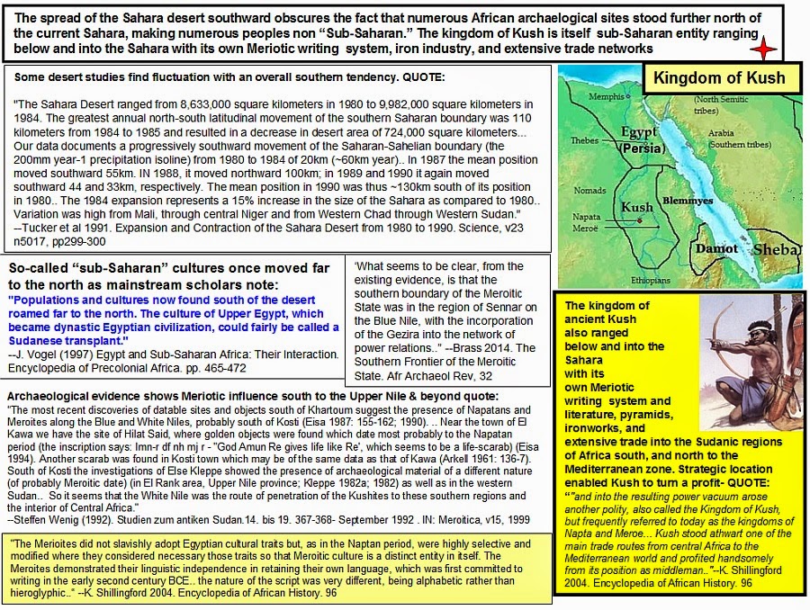 |
|
|
|
Post by zarahan on Oct 24, 2018 17:45:50 GMT -5
Takuri said:
Lot of good stuff in this thread reminding how it was at 1st contact before it came down to
How Europe underdeveloped Africa
Walter Rodney
Bogle-L'Ouverture Publications, 1972
Angela Davis writes the latest edition's foreword.
My opinion?
Shoddy inexpensive mass produced imported implements undermined local manufactures in the market to devastating effect on industry, technology, and engineering.
[/quote][/b]
I remember an old post on ES that showed some descriptions of the 1500s-1600s-1700s
Kongo for example indicate that the people were just as well fed, clothed and housed
as contemporary EUropeans, with about the same standard of living or exceeding.
Any info on this?
The European imports are well known though but what about before the EUropeans came?
How did the Arab imports undermine local production? The slave trade of course
devastated many parts, but what about the manufactures of the various places before
cheap goods from the bazaars of Baghdad or Bombay showed up? ANy info on this angle?
From what I remember on ES Mansa Musa's kingdom was undermined in part by outsiders
though having some internal problems s well. Kush was still going on but outsiders
undermined that too. ANy info on this?
|
|
|
|
Post by asante on Nov 8, 2018 10:00:06 GMT -5
I'm going to tell you that you lost the debate by even acknowledging this narrative that they put out about our history. Our people (assuming that you're of Niger-Congo descent) did not originate in those areas where you're expecting to find extremely ancient civilizations. Research the areas of Africa that we actually came from, and then when we came into our contemporary locations from those original locations.
|
|