|
|
Post by djoser-xyyman on Aug 17, 2014 20:32:06 GMT -5
The overflow from Lake Congo would recreate this paleolake, to an even larger size. It is hard to say what the maximum extent of the lake could ultimately: the hot Sahara climate would cause an increasing degree of evaporation as the lake grows until ultimately the level of the lake would stabilise. This large degree of evaporation would have a large climatological impact on the surrounding areas of the Sahara with increasing levels of rainfall 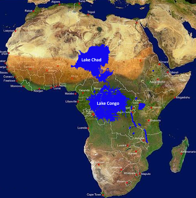 Lake Chad is the remnant of a former inland sea, palaeolake Mega-Chad. At its largest, sometime before 5,000 BC, Lake Mega-Chad was the largest of four Saharan palaeolakes and is estimated to have covered an area of 400,000 km2 (150,000 sq mi), larger than the Caspian Sea is today. This total map of the total African continent shows the massive size of both lakes, in comparison to both existing Great Lakes of Africa (Lake Victoria, Lake Malawi, etc.) and to the size of the continet as a whole. The map also shows ths distinct difference betweemn the two lakes. Lake Congo is a tropical lake while the southern half of Lake Chad lies in the Sahel, and it's northern half in the Sahara. |
|
|
|
Post by djoser-xyyman on Aug 17, 2014 20:32:41 GMT -5
smithsonianscience.org/2010/12/ancient-megalake-discovered-beneath-sahara-desert/ Ancient megalake discovered beneath Sahara Desert In climate change, geology / 10 December 2010 / 1 Comment Beneath the sands of the Sahara Desert scientists have discovered evidence of a prehistoric megalake. Formed some 250,000 years ago when the Nile River pushed through a low channel near Wadi Tushka, it flooded the eastern Sahara, creating a lake that at its highest level covered more than 42,000 square miles.  If they are right the lake last existed before the start of the most recent ice age, or glacial period, and extended 100 miles farther south than proposed by previous researchers
|
|
|
|
Post by djoser-xyyman on Aug 17, 2014 20:33:28 GMT -5
Lake Makgadikgadi is an ancient lake that existed in what is now the Kalahari Desert in Botswana. It may have once covered as much as 80,000 km² and was 30 m deep. The Okavango, Zambezi, and Cuando rivers once all emptied into the lake.  |
|
|
|
Post by djoser-xyyman on Aug 17, 2014 20:36:17 GMT -5
Lake Malawi (Lake Nyasa, or Lago Niassa in Mozambique) is an African Great Lake and the southernmost lake in the East African Rift system, located between Malawi, Mozambique and Tanzania. The third largest and second deepest lake in Africa, it is also the ninth largest in the world. It is home to more species of fish than any other lake,[4] including about 1000 species of cichlids.[5] The Mozambique portion of the lake was officially declared a reserve by the Government of Mozambique on June 10, 2011,[5] and in Malawi a portion of the lake is included in the Lake Malawi National Park.[4] Lake Malawi is a meromictic lake; permanent stratification and the oxic-anoxic boundary are maintained by moderately small chemical and thermal gradients. [6]  |
|
|
|
Post by djoser-xyyman on Aug 17, 2014 20:41:22 GMT -5
Lake Tanganyika is an African Great Lake. It is estimated to be the second largest freshwater lake in the world by volume, and the second deepest, in both cases, after only Lake Baikal in Siberia;[3] it is also the world's longest freshwater lake. The lake is divided among four countries – Tanzania, the Democratic Republic of the Congo, Burundi, and Zambia, with Tanzania (46%) and the DRC (40%) possessing the majority of the lake. The water flows into the Congo River system and ultimately into the Atlantic Ocean. It has an average surface temperature of 25°C and a pH averaging 8.4. Lake Tanganyika is situated within the Albertine Rift, the western branch of the East African Rift, and is confined by the mountainous walls of the valley. It is the largest rift lake in Africa and the second largest lake by volume in the world. It is the deepest lake in Africa and holds the greatest volume of fresh water; accounting for 18% of the world's available fresh water 4 Almost all (98%) of the Tanganyikan cichlid species are endemic to the lake, and Lake Tanganyika is thus an important biological resource for the study of speciation in evolution.[3][7] Among the non-cichlid fish, 59% of the species are endemic.[6] |
|
|
|
Post by djoser-xyyman on Aug 17, 2014 20:51:52 GMT -5
 A map of what the Sahara was like 8,000 to 11,000 years ago, revealing rivers, lakes, swamps and fan-shaped deposits where rivers emptied out. The dots indicate where various kinds of pottery were found Scientists have often focused on the Nile Valley as the corridor by which humans left Africa. However, considerable research efforts have failed to uncover evidence for its consistent use by people leaving the continent, and precisely how watery it has been over time is controversial. In their analysis, Drake and his colleagues found evidence that many creatures, including aquatic ones, dispersed across the Sahara recently. For example, 25 North African animal species have populations both north and south of the Sahara with small refuges within the desert, including catfish (Clarias gariepinus), tilapia (Tilapia zillii), jewel cichlid fish (Hemichromis letourneuxi) and freshwater snails such as the red-rimmed melania (Melanoides tuberculata). Indeed, more animals may have once crossed over the Sahara than over the Nile corridor, the researchers said — only nine animal species that occupy the Nile corridor today are also found both north and south of the Sahara. |
|
|
|
Post by djoser-xyyman on Aug 17, 2014 20:57:55 GMT -5
Researchers from the School of Geography and the Environment at the University of Oxford are surveying the now-dry basin of Lake Makgadikgadi in the Kalahari Desert, which at 66,000 square kilometres is about the same size of present day Lake Victoria. Their research was prompted by the discovery of the first of what are believed to be the world’s largest stone tools on the bed of the lake. Although the first find was made in the 1990s, the discovery of four giant axes has not been scientifically reported until now. Four giant stone hand axes, measuring over 30 cm long and of uncertain age, were recovered from the lake basin. Equally remarkable is that the dry lake floor where they were found is also littered with tens of thousands of other smaller stone-age tools and flakes, the researchers report Giant stone-age axes found in African lake basin Sep 10, 2009 Four giant stone hand axes were recovered from the the dry basin of Lake Makgadikgadi in the Kalahari Desert.  |
|
|
|
Post by anansi on Aug 18, 2014 7:35:41 GMT -5
They are not kidding when they spoke of giant stone axes,is it possible that there is still water to be tapped beneath the surface.
|
|
|
|
Post by truthteacher2007 on Aug 18, 2014 12:52:12 GMT -5
They are not kidding when they spoke of giant stone axes,is it possible that there is still water to be tapped beneath the surface. Yes there is. I believe that Lybia was working on such a project before Khadafi was overthrown. Personally I think investing in desalination would be a better way to go. |
|
|
|
Post by zarahan on Aug 18, 2014 22:15:42 GMT -5
Wow, how big are them axes? How big the folks that wielded them? Just wonderin.. lol That lake reminds me of the Nile River Basin which covers as much as one-tenth of the land area of Africa- all the way to Rwanda and Burundi, and slicing across the Congo to the edges of the Atlantic coast. In a broad, extended sense, it can be considered a Pan-African entity. The Sahara (which is Pan-African)is a key zone of Africa's development and evolution, but I think we should give this broad Nile River Basin zone a similar look as well. 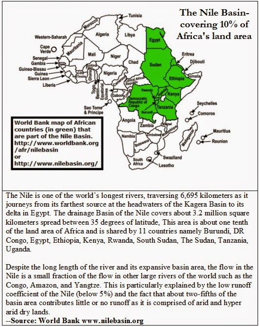 |
|