

Post by anansi on Sept 27, 2014 21:12:31 GMT -5
Stunning Map Found May Prove That Christopher Columbus Was Not First To Sail To America

All school children have memorized the old rhyme “In 1492, Columbus sailed the ocean blue” in order to help them remember the date and the name of the explorer who “found” America.
But new evidence, including a map, indicates that there may need to be a different date and a different name.
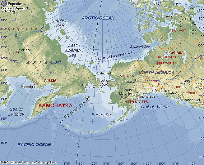
The incredible discovery of 14 documents kept in the trunk of an Italian immigrant who settled in San Jose, California, may change history. In particular, the map found among the documents could be an incredibly stunning find. Crudely drawn on sheepskin, the map depicts what appears to be the Bering Straight, Alaska, the Aleutian Islands and the west coast of North America — specifically, Washington state.
The map also indicates that it was Marco Polo, not Christopher Columbus, who made the voyage, and that it happened in the 1200s.
The documents recount how Polo met a Syrian trader on the Kamchatka Peninsula, located on the far eastern edge of the Asian continent. The trader told Polo of a land that was a 40-day voyage east from the peninsula. According to The Smithsonian, the map and documents consist of “hitherto untold encounters with a Syrian navigator, a band of lance-toting women in ermine pelts and people on a peninsula ‘twice as far from China’ who wear sealskin, live on fish and make their houses ‘under the earth.'”
The documents claim then that Polo crossed the Bering Sea and headed straight to North America, and the map seems to be visual support of that claim. It seems as though Polo sailed around the Alaskan coast, the Aleutian Islands, then headed east to British Columbia before heading down the Canadian coast, eventually reaching Washington state.
As The Smithsonian says of Polo, “For a guy who claimed to spend 17 years in China as a confidant of Kublai Khan, Marco Polo left a surprisingly skimpy paper trail. No Asian sources mention the footloose Italian. The only record of his 13th-century odyssey through the Far East is the hot air of his own ‘Travels,’ which was actually an ‘as told to’ penned by a writer of romances.” And there has always been something noticeably missing from what Polo did pen downs — maps. He never drew any maps of any of his travels.
But if the map and other documents are genuine, it wasn’t Marco Polo who drew the map and made the claims, but rather his three daughters — Bellala being the most prolific, but her sisters’ signatures show up on some documents, as well. If authentic, the map and documents would indeed change history. The map shows, after all, that Polo recorded the Alaskan coast, as well as the Bering Strait, four centuries before Vitus Bering, and that Polo was aware of the New World’s existence some two centuries before Columbus set sail.
link removed possible infection by warning on my P.C
If the above map is real then it was a Chinese discovery rather than Marco Polo he may have been just along for the ride,but it is fascinating to see traders going travelling to the far edge of the Asian continent to to business the man met a Syrian in Kamchatka.
New link www.georgianewsday.com/news/regional/291126-map-shows-marco-polo-may-have-discovered-america-in-the-the-13th-century-200-years-before-christopher-columbus.html
But new evidence, including a map, indicates that there may need to be a different date and a different name.
The incredible discovery of 14 documents kept in the trunk of an Italian immigrant who settled in San Jose, California, may change history. In particular, the map found among the documents could be an incredibly stunning find. Crudely drawn on sheepskin, the map depicts what appears to be the Bering Straight, Alaska, the Aleutian Islands and the west coast of North America — specifically, Washington state.
The map also indicates that it was Marco Polo, not Christopher Columbus, who made the voyage, and that it happened in the 1200s.
The documents recount how Polo met a Syrian trader on the Kamchatka Peninsula, located on the far eastern edge of the Asian continent. The trader told Polo of a land that was a 40-day voyage east from the peninsula. According to The Smithsonian, the map and documents consist of “hitherto untold encounters with a Syrian navigator, a band of lance-toting women in ermine pelts and people on a peninsula ‘twice as far from China’ who wear sealskin, live on fish and make their houses ‘under the earth.'”
The documents claim then that Polo crossed the Bering Sea and headed straight to North America, and the map seems to be visual support of that claim. It seems as though Polo sailed around the Alaskan coast, the Aleutian Islands, then headed east to British Columbia before heading down the Canadian coast, eventually reaching Washington state.
As The Smithsonian says of Polo, “For a guy who claimed to spend 17 years in China as a confidant of Kublai Khan, Marco Polo left a surprisingly skimpy paper trail. No Asian sources mention the footloose Italian. The only record of his 13th-century odyssey through the Far East is the hot air of his own ‘Travels,’ which was actually an ‘as told to’ penned by a writer of romances.” And there has always been something noticeably missing from what Polo did pen downs — maps. He never drew any maps of any of his travels.
But if the map and other documents are genuine, it wasn’t Marco Polo who drew the map and made the claims, but rather his three daughters — Bellala being the most prolific, but her sisters’ signatures show up on some documents, as well. If authentic, the map and documents would indeed change history. The map shows, after all, that Polo recorded the Alaskan coast, as well as the Bering Strait, four centuries before Vitus Bering, and that Polo was aware of the New World’s existence some two centuries before Columbus set sail.
link removed possible infection by warning on my P.C
If the above map is real then it was a Chinese discovery rather than Marco Polo he may have been just along for the ride,but it is fascinating to see traders going travelling to the far edge of the Asian continent to to business the man met a Syrian in Kamchatka.
New link www.georgianewsday.com/news/regional/291126-map-shows-marco-polo-may-have-discovered-america-in-the-the-13th-century-200-years-before-christopher-columbus.html

